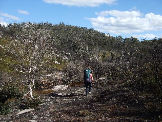
Kynie crosses recently bushfire burnt countryside near Canowie Brook
CORANG CIRCUIT TO BIBBENLUKE RIDGE & BEYOND
Between Monday September 8th and Thursday September 11th 2014, fellow Shoalhaven Bushwalker Kynie Evison and I did some walking in the Budawangs. This was my 2nd hike here this year and the reason for the hike was that I wanted to check out and list all the campsites near Bibbenluke Ridge with my GPS for future reference. I found that Kynie had taken a look at the Burrumbeet Brook camping caves during a recent NPWS maintenance weekend and was interested in listing them properly. There were also a few other options we could look at too. The Shoalhaven Bushwalkers require a quorum of four walkers to make an activity an official club event and seeing there was only two of us it meant we weren't covered by the club's guidelines though we did take the precautions of having a PLB (Personal Locator Beacon), GPS receiver and topographic maps.
Rather than having to get up early for the long drive from Canberra to the Wog Wog Trackhead on the Monday morning, I decided to drive over on the Sunday afternoon and sleep in my car overnight, enjoying a car camp style meal and a couple of chilled bourbons. I had done this earlier this year and it worked quite well. Having arrived at the drive-in campsite just off the Charleys Forest Road, better known as the Mongarlowe Road south of Nerriga, I met up with Chris, a fellow enthusiast from near Katoomba in the Blue Mountains who was driving around New South Wales and camping overnight in little known wilderness roadside campsites. After having my meal Chris invited me to join him at his campfire and we enjoyed a few alcoholic beverages and chatted until late at night when it became too cold to stay outside any longer.
Monday 8th September 2014 - It was a clear sunny morning, but very chilly when I awoke at 5.55am at first light. I had a fitful sleep in the Rav4 overnight, but still managed some decent shut-eye. I fixed a quick breakfast and got changed into my hiking clothes then waited until Kynie arrived. By 7.30am the rising sun started to warm me up. Chris had packed up and left at 8.30am and Kynie arrived soon after at 8.45am. We headed out onto the track at 9.00, following a narrow path that descended to Wog Wog Creek. After crossing here we followed the trail as it ascended through old farmland dominated by grey ghost gums. The track ascended to an outcrop of individual conglomerate rocks known as Tinderry Rocks and takes just under one hour to reach. From here the track descends and ascends through the forest before starting to ascend towards Corang Plateau.
Today though we are following a different route. Kynie wanted to check out the alternate route to Canowie Brook via the Corang Cascades as she had never done this section from the cascades before. I had only done it coming from the other end so I was a trifle nervous about following the route. It had been nearly 10 years since I had last walked this section.
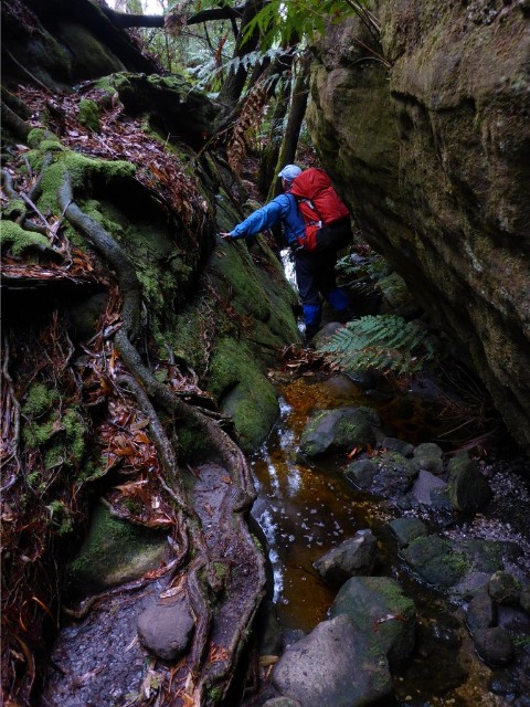
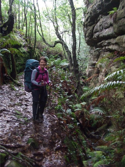
At a well marked tree we turned left and followed a distinct trail north. The trail did occasionally fade out, but not for too long and we soon found ourselves back on track without getting misplaced. After descending a short rocky section we arrived at Goodsell Creek. It was just after 10.30 and we decided to stop for a short morning tea. Kynie tried the new map app on her iPhone and found it worked perfectly, stating our position quite accurately.
After morning tea we continued on, ascending and descending every time we needed to cross small creeks, but soon enough we arrived at the Corang Cascades camping area next to the Corang River. We had both seen these cascades up close on previous trips so there was little need to view them again. We were keen to find that route to Canowie Brook and still had a long day ahead. We located the track behind one of the camping spots and followed this through the scrub to Broula Brook with the aid of several rock cairns. We crossed the brook at 1.00pm and decided to have lunch at one of the quaint campsites here that had a nice log to sit on.
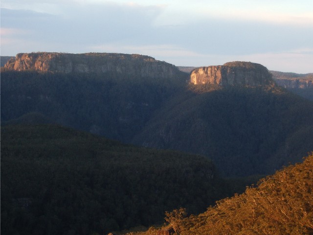
30 minutes later we were off again following a track that was quite well defined despite an obvious lack of walkers. Some sections were easy to follow, others not so, however, ribbons and cairns helped keep us on the right track. We now started to climb steeply, away from the river which was about to enter a gorge of rock ribs. Our route took us high onto the ridge where we caught site of a tree interrupted waterfall, then we entered an area of bushfire burnt country, part of the same fires that had swept across Corang Plateau last September. The fire must have been extremely hot here as nothing has yet regenerated. Despite this it was still very hard to follow the correct track as there were many that had been created by both animals and misplaced Bushwalkers when the vegetation was overgrown. We had no luck in finding the viewpoint down to the river from one of the high rock ribs and decided to give this a miss.
Kynie crosses recently bushfire burnt countryside near Canowie Brook
We now followed the burnt country into Canowie Brook. By now our rucksacks were black from the charcoal blackened trees and scrub and I had taken a tumble that ripped a hole in the knee of my trusty Mont hiking pants. The trail became more defined as we descended into the valley and followed the brook towards the flood plain. The fires had cleared the overgrown campsite that Gary, Vicki and I had abandoned a couple of years ago, it looked good enough to camp there now.
We followed the boggy track past the big pool and cascade where on many previous trips we had bathed or collected water, and made our way across the plain to the bottom of Corang's conglomerate slope. The campsite here was being used, but we hadn't planned to use it this trip. We crossed the swamp on the familiar duckboards and collected water from the small creek on the other side. We then ascended the track which passed Profile Rock Hill's western flank and looked across at Burrumbeet Brook.
Kynie was keen to utilize a cave near the new drop toilet but it was obvious the trails here we're not right. After collecting water from the brook for our cooking we headed along the track to the easternmost cave of the group, and largest to camp the night which we have renamed the 'Burrumbeet Hyatt'. The NPWS had done maintenance work here recently and a new track had been cut, negating the need to take a very wet and boggy lower trail. We arrived at our cave at 4.45pm and immediately set up our sleeping areas, then headed off to collect firewood and then unpack our rucksacks. An afternoon cup of tea or coffee was in order before we cooked our dinners at 6.15pm and got the fire going. It was turning quite cold and no time was wasted getting into merino thermals and down jackets. We retired to our sleeping bags at 8.10pm.
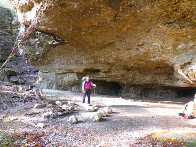
Kynie at the Burrumbeet Hilton Camping Cave
Tuesday 9th September 2014 - We were both up by 7.20am after a reasonable night's sleep. I was warm enough and comfortable under the circumstances of sleeping on a hard cave floor. Outside it was a little overcast but the clouds soon cleared. It was going to be another fine sunny day. Whilst doing my morning duties I discovered a smaller cozier cave heading back along the cliff line not 50 metres from our cave - I made a mental note about this for future hikes. It would easily fit 2 hikers and possibly 3 snugly. Back at camp we fixed breakfast then packed up in an effort to be out on the track by 9.00am.
Following the now reasonably and recently maintained track, we headed eastwards through a swamp, mostly on duckboards and wondered why NPWS had not re-routed the track along here like they had at Burrumbeet Brook. The going was still rough but Kynie informed me that most of the track maintenance had been earlier and on Bibbenluke Ridge. We ascended to a rock formation which marked the track to Yurnga Lookout. By now the sky had again turned grey.
We now ascended to the top of the ridge where we were greeted by the usual clearing. We knew to turn right, but what greeted us looked wonderful. The once overgrown track had been cleared here and instead of branches and bushes catching on our clothing we were able to make progress unhindered. As we made our way across the ridge top we became aware of the stiff winds and they were quite chilly. Rather than grabbing warm gear from our packs we gritted our teeth and forged on hoping our exercise would keep us warm, which it did.
Soon the rocky bluffs of Mt Tarn appeared in the north-west along with Mt Hoddle, part of Mt Haughton and to the south, Mt Owen. The track was still quite boggy along here and we were thankful there were still duckboards in place. We started to descend to a creek and I prepared myself for one of the main reasons I had put this walk on. When I had come through here in June I noticed a lot of trails heading off to the north from the track between Bibbenluke Camp and here. Although it was obvious they led to campsites I still wanted to check them out in case they made better sites than the well known Bibbenluke Camp. I had even brought along my GPS to mark the track heads and the spots they led to.
Our first side track was reached and we dropped our heavy rucksacks to check out where the track led. It soon petered out, but rock cairns showed we should continue on. I was thinking this may lead to the long unfound camping cave I had been hearing about and had tried to locate for so many years. I was right. After negotiating a narrow gully and scrambling over some rocks I noticed another cairn ahead. Just beyond it was a great looking overhang that had enough sleeping spots for about 4 people, a nice rock circled fireplace and a large log and small cut log to sit on. Kynie and I were ecstatic that we had found this place. The only downside was the amount of wind that came through, but thatís the same with all the caves. The only water available can be obtained in the gully below which has to be gathered after a reasonable scrub bash, unless it can be carried in.
We now returned to the rucksacks at the track. Kynie had marked a camping cave she had seen on a sketch map and it was marked on her topographic map about 400 metres west from the one we had just visited. We left the rucksacks here and walked back towards Burrumbeet Brook. We didn't have far to go before we needed to look for some kind of route in after Kynie paced out the steps needed. We made our way into the scrub, doing our best to avoid the prickly hakea but had no luck finding this cave. We came to the conclusion that this cave was incorrectly marked on one of the old sketch maps and it was this cave that we had found.
We headed back to our rucksacks and continued on, but we didn't have far to go before we found another foot track heading off into the scrub. Dropping our rucksacks and taking another GPS reading we again set off. Eventually the faint track took us to another camping cave, the same one we had found earlier, though via a much easier route in. We returned to our packs. Before we arrived at Bibbenluke Camp we had found 3 more side tracks and all of them led to quaint single to three tent sites less than 50 metres in from the main track. The last one was definitely the track Gary Williams and I had followed to a half decent site in 1996, but most of that had become badly overgrown with hakea and banksia. Full details, photographs and map references of these tracks can be found on this website by clicking here.
Kynie and I arrived at Bibbenluke Camp at 1.15pm and stopped for lunch. Our original Plans were to don day packs after lunch and walk to Mt Tarn to explore before returning here to put up tents for the night. However, the sky looked grey and threatening and with bivouac style tents neither of us wanted to spend a wet night here. We agreed to head for Mt Cole and try to reach Sunset Cave near Donjon Mountain this afternoon.
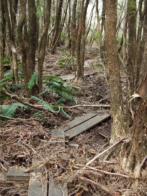
The duckboards in the forest below Bibbenluke Ridge near Bibbenluke Camp
It was 2.00pm when we left Bibbenluke Camp and returned to the trail which took us through duck-boarded forest until we met up with the track coming in from Mt Tarn. Now we followed the immediate track to the right, marked only by a half scrub-covered duckboard. The track led us through thick forest and was well defined, though many fallen trees created obstacles or detours. We crossed a very small creek and then ascended a ridge where we got some tree interrupted views of Mt Donjon in the distance. We descended to the old camping saddle, noting there wasn't much room left for tents here now it had become badly overgrown. Now we had a steep ascent up the slope to Mt Cole and it's many camping caves. Finally we arrived at the top at 3.30pm. The ninety minutes had gone faster than we imagined. Not content with the large open overhangs of Mt Cole we agreed we had plenty of time to get to Sunset Cave near Donjon Mountain, one of Kynie's favourite camping caves.
Now we followed a faint track that contained rocky obstacles, fallen logs and thick sharp leaved sword grass, a track that sometimes contoured the top of very steep slopes. Occasionally we passed through large camping caves (overhangs), there was one very slippery section to cross a creek and then a slippery track that had us ascending another steep rise. Once up top we came to a metal Monolith Valley sign. We passed this and continued following the trail as it passed through a mossy green rock strewn gully. There wasn't much water flowing here despite the region's recent rainfall and Kynie had hoped we could top up our water supplies here. We found a small cascade, very small that gave us tea coloured water for our cooking tonight. One 3 litre hydration bag topped up and one 4 litre wine bladder and we were off again, scrambling up the trail with rucksacks that were now about four kilograms heavier. Thankfully we didn't have far to go.
Within 20 metres we spied a side track heading off to the left and followed it. We scrambled up some rocks at a small pass, turned left and stepped into Sunset Cave at 4.35pm. It had taken us just over one hour to cover this distance, including water collection, but the track had been very rough and we were carrying full packs, not day packs as is usually the case. It was quite windy here, but the sleeping areas had rocks piled up to protect the sleeping hikers from the strong winds that roar up the valley to this spot. After some deliberation on choice of sites, I took a spot under a low overhang not halfway into the cave while Kynie chose a well wind protected spot at the far end.
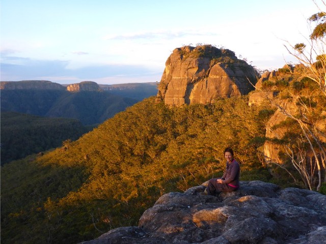
Kynie sits on the rock platform as sunset descends on Donjon Mountain behind
After unpacking the rucksacks we went through the scrub to a rock platform to check out the spectacular views. Last time I was here it had rained heavily and we had spent all our time in the cave. After a short scrub bash we stepped out onto a large rock platform that gave us sheer drop views of Hollands Gorge and looked across to the eastern side of Mt Tarn, Quiltys Mountain, Mount Sturgiss and for the first time, a full view of Mt Elliott. Just along the cliff line to the east stood Donjon Mountain and it was magnificent in the full light of the setting sun. The weather we were fearing did not eventuate and the skies were blue all the way. Kynie and I discussed tomorrow and agreed we would probably head back to Bibbenluke Camp and maybe do the exploratory of Mt Tarn, weather permitting.
Looking across Hollands Gorge towards the square Mt Elliott and behind it, Mt Sturgiss
At 6.10pm we prepared our dinners and got the fire going. Kynie retired for the night at 8.45pm while I continued writing on my iPad, heading to my sleeping bag some 15 minutes later. The wind was now howling through the cave. Before I got to sleep I noticed the way I set my bedding up meant my feet were higher than my head. The slope in the cave was very small but enough to make me feel uncomfortable. I fixed this by rotating my bedding 45 degrees. By 10.00pm the wind had really got up to gale force, though I was quite warm in my sleeping bag. I noticed something fly past my face and suspected the wind had picked up one of my dry bags I had put on one of the rock shelves in the cave. I got out of my sleeping bag to check where I had placed everything and found it was the stuff sack for my Thermarest mattress, which was the only item missing. Despite using my head torch, I could not find it, obviously the wind had carried it further away. Nothing I could do now. I returned to my sleeping bag and went to sleep. I woke up at some time during the night to find it was raining quite heavily, luckily I was able to keep my gear and myself dry even though at times the wind drove a fine spray into the cave.
Paul scrambling out of the gully whilst heading back to Mt Cole from Sunset Cave
Wednesday 10th September 2014 - I was again up at around 7.15am. The rain had stopped and the sky was clearing, but the wind was still blowing very strongly. I quickly located my stuff sack that had blown away last night, over by the entrance some 50 metres from my sleeping spot. The bag was wet and sandy but undamaged. We fixed breakfast then started packing up. Before we left we took another look at the surrounding mountains from the rock ledge, however, the light wasn't good enough to take photographs. The sky was still very overcast. We left the cave at 9.50am and headed back to the main Mt Cole camping caves. The surrounding scrub was soaked from last night's rain and our clothes soon got quite wet, a bit late to put on wet weather gear now. The rocks and ground cover were very slippery so we took our time and made sure our footing was right. We took a number of photographs in one of the mossy gullies and noticed they came out quite bright, especially those I took under my camera's museum mode. There were a couple of mishaps along the way where we ended up with jarred knees or sore shins, but nothing serious and within one hour we were back at the main Mt Cole camping cave I have often used and we stopped for a 30 minute morning tea break and the chance to remove our warm jackets and dry off.
Kynie in the same area as the gully photo above
By now the sun was coming out, though there were still threatening clouds about. We set off and descended the Mt Cole slope, crossed the saddle then did the long ascent. Finally at the track junction we took the Mt Tarn track which turned out to be very wet underfoot, to the intersection to the access track to Bibbenluke camp, arriving there at 12.45pm, just in time for lunch. The sun was out, the clouds now mostly white and we had dried out. The waterfall was in full flow and I topped up some water and got a leech. Luckily it didn't get any of my blood, but we had to now be careful. There were suddenly lots of March Flies about as we attempted lunch, it was getting quite warm.
It was decided after much discussion that rather than pitch a tent here and then walking to Burrumbeet Brook tomorrow, that we head there today and have the ability to head home a day early. Neither of us really felt like taking the steep ascent to Mt Tarn just to check out a couple of camping caves and Kynie wasn't keen on tenting tonight, so at 2.00pm we shouldered our rucksacks and headed for Bibbenluke Ridge.
The sky was beginning to clear, but there was still a strong gusty wind that chilled us as we made our way across the ridge and past all the recent maintenance work, then we descended past Yurnga Lookout and into the Burrumbeet Brook valley, finally arriving at the same cave we had used on Monday night, the newly christened 'Burrumbeet Hyatt' at 3.50pm, less than 2 hours after leaving Bibbenluke Camp.
With time on our hands we decided to log all the worthy camping caves along this cliff line of Burrumbeet Brook, taking just my GPS, notebook and camera, plus our water bags to fill up by the creek at the end and we set off, first marking the co-ordinates of our cave and the cave nearby which has now been christened 'Borstals Cave'. We then followed the cliff line, mostly scrub bashing as we went and found one other very good overhang before arriving at the last two caves which have become well known to me and some of my friends from hikes in the late 1990's to early 2000's. There were many other overhangs though, but they were deemed unsuitable for camping due to being very open and available to strong winds or had badly sloping floors. The main sites were logged and all had tracks leading to them from the main track at Burrumbeet Brook.
The final cave had a couple of hikers from Sydney and we chatted to them for some time before we followed the track down to the Burrumbeet Brook camping area and gathered water at the same spot we had on Monday. By now the clouds had fully cleared and we were greeted by a clear sunny blue sky, hopefully this was the end of the forecasted rain. After last night's downpour the water was flowing very fast and we easily filled our water bags. We returned to our cave, 10 minutes walk away and arrived there at 5.30pm. We immediately set about organizing our bedding for the night in the same places we used on Monday, then at 6.30pm after a well earned cuppa, we prepared and ate our dinners. We both retired to our respective sleeping bags at 9.00pm.
View of the Burrumbeet Brook valley near the pass in front of Profile Rock Hill
Thursday 11th September - I was up at 6.10am and Kynie a little later. Fixed breakfast and started packing up. Had my best night's sleep last night and Kynie concurred. It's a clear sunny morning though there is a cool breeze blowing through the valley. Before we moved out a couple of large Magpies flew into our camp and roosted on the rock near the campfire. I tried throwing a couple of nuts their way and they were greedily snapped up. It was obvious these birds were fed regularly by hikers and they weren't the last wildlife to come begging for food today. We moved out onto the track at 8.20am and headed for Profile Rock Hill pass and across the swamp to Corang Camp but not before filling up at Canowie Brook at the bridge. Corang Camp had steel chests belonging to NPWS, but where were they doing track maintenance this time? There was a large tree that had been cut into circular sections and dumped next to the communal fireplace. Kynie was quite impressed with the camp.
We now ascended the slope noting the bushfire damage from last September. The steps were quite tiring, but exactly on the hour (9.20) we arrived at the foot of the conglomerate slope onto Corang Plateau. After a short breather we set off. Despite its imposing size and height the slope is easily climbed by grabbing hold of the conglomerate pebbles for hand holds and foot holds and we needed them, the wind was very strong and we felt it could blow us over the cliff edge at any time. Also, the fires had burnt away the vegetation leaving an open void, though one remaining bush became my saviour.
Near the top of the ascent a very strong gust of wind took my beloved Manchester City cap away and I watched helpless as it flew towards the edge of the cliff and oblivion below. However, the wind dropped just in time for the cap to land in the one single bush on the edge of the cliff, not far from Kynie and she was able to retrieve it. The cap was put somewhere secure - inside my shirt. I was thankful to that little bush for saving me having to go back down to the Corang Campsite and search the base of the cliff for my cap. I wasn't leaving without it, it was a special gift from a special friend.
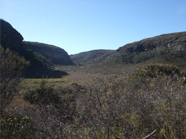
Continuing on we made our way across bushfire burnt Corang Plateau, battling the strong gusts of wind coming from the west, which was where we were heading. We quickly passed by Corang Arch and there was no way we were going to stand on top of that in this gale, not without suicidal tendencies. We headed for Corang Peak and at the track intersection made the decision which track we would take. Originally I was thinking of taking the track to the top of this cone shaped hill for some good views, but the strong winds and Kynie helped me changed my mind, we would follow the track around the peak's southern flank.
We also discovered why there was NPWS maintenance gear at Corang Camp as we passed many bundles of helicopter dropped wood and metal grid footpads. I was amazed they were going to remove the wooden duckboards and replace them with metal when there are many other areas requiring immediate service and although some of the duckboards here were burnt in the fires, the majority were only singed. As before, it was wonderful to walk open country without battling against overgrown vegetation and the views were still quite good. It wasn't long before we were passing Korra Hill and soon after we stopped on a small rock slab with views over a cliff to the valley below where we had a short morning tea.
Continuing on through burnt country we started descending a boggy section of track, now this looked like it needed some serious maintenance work. The gaps between the old wooden steps were filled with water and several contained tadpoles and young frogs. As we came across a flat section, Kynie noticed a rock cairn on the side of the track and what appeared to be a faint trail heading into the now burnt scrub, suddenly revealed after the fires. On a hunch we went to see where it led. The fire blackened scrub brushed at our clothing, making us black very quickly. We followed the track for a short distance before Kynie realized we had found the long lost track to Sneddon Pass.
It wasn't much further on that the fire burnt country was left behind and we were back dealing with thick scrub most of the way as we made our way to the western most point of Corang Plateau and the negotiation of Borstal's Pass. We then descended to the track intersection where we had walked in to Corang Cascades on Monday, before we entered the forest and followed the well defined track up to Tinderry Rocks, arriving at our usual lunch stop at 1.05pm.
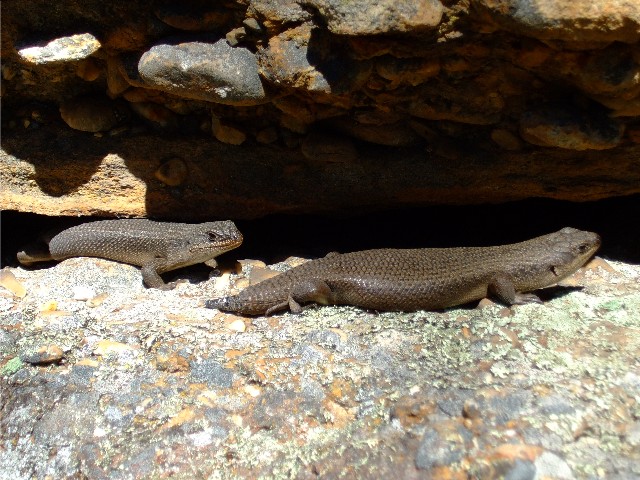
The two skinks discovered at our lunch site at Tinderry Rocks
As I dropped my pack next to the large conglomerate rock I noticed a small head appear from under a ledge. It was a rather large skink who was growing a new tail. Kynie and I were even more surprised when its mate also appeared and they certainly didn't seem bothered by our presence. I deduced that these two lizards were used to being fed by resting hikers, this being a popular stopping point one hour out from Wog Wog. I threw them some crumbled nuts which were quickly devoured, along with some morsels of cheese and salami that Kynie offered. I would be interested if these lizards were still here next time (They weren't).
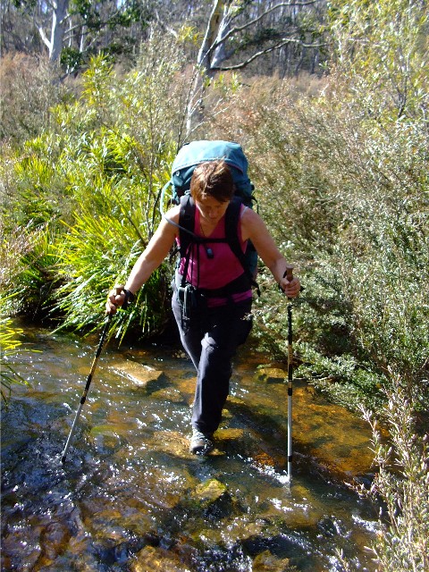
Kynie negotiates Wog Wog Creek
By now it was becoming quite hot and the sky was totally cloudless. We set off on the final leg of our hike at 1.25pm, following the well defined trail through the forest, past some old ruins of a farm building and descended to a fast flowing Wog Wog Creek, which we crossed without incident. We just had the short ascent up to the car park, which seemed to never end. Suddenly, we topped a rise and saw our cars parked in one of the bays. We had arrived there at 2.20pm, just 55 minutes since we left our lunch spot. We wasted little time in changing our footwear, putting our rucksacks in the car and enjoying a stubbie of beer each from the car fridge. They were still cold after four days and went down a treat. We now had to get to the Nerriga Pub some 25 kilometres away by 3.00pm before the kitchen closed so we could celebrate another successful hike with a plate of their delicious hot chips washed down with a schooner of ale in the new beer garden, and we made it with minutes to spare.