At 9.00am on Thursday 16th May, Brett Davis, Gary Williams and I arrived at the Wog Wog Trackhead to commence our 5 day Budawangs trip. We headed out, passing the new plaque at the side of the track. I noticed the main track had become quite overgrown since my last visit here, especially as we descended to Wog Wog Creek and just after its crossing. The weather was quite chilly, but the cloudy sky was clearing. We crossed Wog Wog Creek and ascended the main ridge which leads to Tinderry Rocks. The ascent was much easier than I remember and it was not long before we were walking along through flat open forest and by 9.50am we were having a break at Tinderry Rocks. Brett commented at this point that Gary had been very quiet during the walk. A quiet fellow by nature, especially around people he did not know. I warned Brett that by day 3 we would not be able to shut him up.
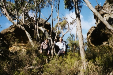
Gary & Brett prior to the ascent onto Corang Plateau - Photo: P. Ellis
We continued on, the sky now blue and ascended to Corang Plateau. We had a quick break to views of Wog Wog Mountain before again continuing towards Korra Hill. The track alongside Korra Hill is well remembered as being a nightmare. A narrow muddy, slippery track with the surrounding bushland snagging at our packs. I remember Dave's dislike of this track in 1999, however, since then, major track work has been done with duckboards positioned the entire length of this section and the scrub cut back, making our progress not only much easier, but also faster. With Korra Hill behind us, we attempted to locate the track to Admiration Point. This effort did not meet with success and our only reward was a great view of Pigeonhouse Mountain. Disappointed we set about the ascent to Corang Peak. Again there have been wooden blocks positioned along the ascent to aid walkers and ease erosion of the track, but these wooden blocks sometimes made our ascent that little bit tougher. We arrived at the summit gasping for breath at 1.05pm and found a spot to have lunch.
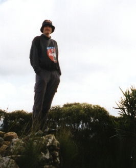
Brett Davis on top of Corang Peak - Photo: P Ellis
The views from here were as magnificent as always. West to Korra Hill, Wog Wog Mountain, Admiration Point and Wirritin Mountain in the distance. To the south we could easily make out the double hump of Mt Dromedary. To the North, we had great views of the Goodsell Basin and to the east, great views of Mt Tarn, Mt Owen and Bibbenluke Mountain. As we were packing up our gear for the descent we were joined by a group of 18 walkers from a Canberra School who were amazed at our plans to spend 5 days exploring the Budawangs. We descended the eastern slope of Corang Peak and headed for the descent to the north which would take us to Canowie Brook. There was new track work here too and once we reached the rock platform, Brett tried to locate a view of Corang Arch from this side of the plateau and was quite bewildered when he could not locate any sign of the arch. The reason for this was soon revealed as we soon found ourselves standing above the arch. We reasoned that the original track to our intended descent had been closed off, with the new track now taking us straight to the arch and the descent down the conglomerate slope.

Corang Arch - Photo: B Davis
A photo shoot was called for and we dropped packs. I was still rather nervous standing on the cliff edge looking down onto the arch, especially with the strong winds blowing, as is the norm for this area. However, Brett positioned himself on a high ledge and happily snapped away. Gary and I decided to enter the access cave and take a safer look at the arch. We entered what seemed to be a large hole in the ground, but which obviously was the beginning of another arch. Once under the roof we noticed that Corang Arch was quite accessible. We were joined by Brett who made his way across to the caves under the cliffline to take photographs of the arch with the view of the valley below, seen through the hole. We joined him to take our own photos. Brett then climbed up and stood on top of the arch, giving me the chance to photograph him. He then cajoled me to climb up and join him and before I knew it Gary and I were standing on top of Corang Arch with a strong wind buffeting us while Brett returned to the top of the cliff to take photographs. Once taken we wasted little time in returning to our packs and with my words of "Brett Davis, You've Done It Again" we headed off for the descent down the conglomerate slope.
In previous trips we had always negotiated the conglomerate slope as an ascent, feeling it was too steep to consider descending. However, we found the descent quite easy and no problem at all. We soon found ourselves standing on the Canowie Brook Plain, taking photographs of Profile Rock Hill before continuing across the swamp and climbing the small ridge which would take us to Burrumbeet Brook. As we entered Burrumbeet we were again quite surprised to find more track work had been done, including the positioning of signposts at one section where the track can become quite a maze. It was 3.00pm when we ascended the short hill to the camping caves on the southern side of Burrumbeet, claiming the same cave that Gary, Dave and myself had used 3 years earlier. Brett was not too impressed with the level of the sleeping area, so he moved his gear to a more level section 100 metres away. However, he joined us in hunting for firewood and stayed with us until it was time to hit the sleeping bags.
We got a good fire going, but the strong winds continually threw up embers from the fire, forcing us to keep the fuel level low. We did not mind, it meant we were able to keep the fire going until well after 7.30pm. It was at 6.45 that Brett suggested we take a torchlit walk down to the open Burrumbeet Brook Plain. Here he gave us a quick astronomy lesson, pointing out such constellations at Scorpio, Leo etc. We were also treated to sights of shooting stars and satellites flying overhead. The increasing cold conditions meant we did not stay long and we soon returned to the campfire lit campsite until 8.00pm when we all retired to our sleeping bags.
I had a great nights sleep. The new sleeping bag certainly did its job, despite my earlier reservations. I woke up next morning just before 7.00am to the flash of Brett's camera and the words "It looks like a beached walrus". We had a quick breakfast, packed up our gear and headed off at 8.35am. Again the skies were blue, but the wind was still blowing hard. We stopped to refill our waterbags at the Brook. We now only had one between us as Gary's waterbag had split during packing that morning. Brett was carrying only a small waterbottle, but he does not share Gary's or my thirst.
During the walk out of Burrumbeet Brook we stopped to take a look at a rather large cave at the far eastern end of Burrumbeet, only 15 minutes walk from the cave we stayed in overnight. A cave we came to name as the Burrumbeet Hilton. Brett made a mental note to include this cave for future nights in the Burrumbeet area.
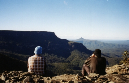
Gary & Brett enjoy the views from Yurnga Lookout - Photo: P Ellis
We crossed another swamp and negotiated yet more badly eroded tracks, still to be upgraded no doubt, though there were some duckboards placed at the worst affected sections. We dropped packs at a small track intersection and took the short walk up to Yurnga Lookout. The wind up here was even stronger than at Corang Arch, and much colder. We wasted little time up here, pausing only to admire the excellent view of the scenic rim which included Bibbenluke Mountain, Mount Owen and Pigeonhouse before returning to our packs for the steep climb to Bibbenluke Ridge. Once on the ridge we were treated to more excellent track work in the form of more duckboards for most of the traverse. This section of track has always been difficult to cross and the old slippery trail has claimed it's share of tumbles in the past, but not this trip. It was only 11.15am when we arrived at a new campsite on the southern side (or Bibbenluke Mountain side) of the Bibbenluke Camp.
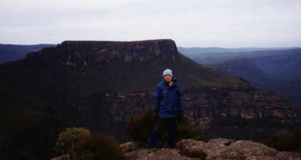
Gary & Paul on the new improved Bibbenluke Ridge Track, Mt Tarn in background - Photo: B Davis
We had a quick lunch, then loaded up the daypack for the side trip to Bibbenluke Mountain. Brett led the way up the steep scrub covered slope to the tree line and through to the base of the cliffs. We then skirted around these looking for an ascent onto the summit. Brett soon found this and we started our climb. There was only one difficult section, a narrow ledge which had to be climbed using the help of a small tree growing out of a crack in the rock. Brett talked us through this section which we managed with some trepidation. I was not looking forward to the descent. Once on top we were treated to some magnificent views, including a never before seen view of Corang Plateau from this angle. We attempted to cross Bibbenluke Mountain for more views, but not only was the scrub rather thick and impenetrable, it was also quite deep. After several attempts at trying to cross, we returned to the cliff edge for our descent. Surprisingly the ledge gave me little trouble as we descended and I heard myself uttering "Brett Davis, You've Done It Again" once more.
Paul on the summit of Bibbenluke Mountain with the Corang Plateau in background - Photo: B Davis
We descended the hill and returned to our packs. We only had a short distance to travel to the main Bibbenluke Camp, once again made very easy by the placement of duckboards and wooden blocks along the track. Even Bibbenluke Camp has been improved with new campsites created. We topped up our water supply for the trip to the Mount Cole Camping Caves, then headed up to the Mt Tarn Ridge.
As we arrived at the intersection of the Mt Cole track we were joined by two bushwalkers who had caught up to us after coming off Mt Tarn. Brett immediately struck up a conversation with them but quickly took a dislike to the female walker with the way she boasted about how long they had been walking. They were also heading for Mt Cole but started walking in the wrong direction until Brett took great satisfaction in pointing them the right way. We let them get a fair distance ahead before we followed, hoping they would not be taking residence in the cave we had planned for the night.
The track to Mt Cole was much the same as it had been 3 years before, in places very narrow with the vegetation closing in. However, we could see evidence that improvements would soon be undertaken as we passed many bundles of lumber placed at strategic points during the walk. We were most relieved to find our designated cave unoccupied after the ascent to the cliffline of Mt Cole. We dropped our packs at 2.45pm, claimed our sleeping areas. Brett even set up his tent under the overhang for extra protection from wind driven sand. We again collected firewood and after we cooked up our dinner, sat around the campfire and talked well into the night. Subjects included favourite movies and music. Brett even commented that I was quite correct about Gary, it was becoming quite hard to shut him up. With our wood supply dwindling we retired to our sleeping areas at 9.40pm.
We had another good nights sleep, waking at 6.55am on the Saturday morning to overcast skies. We were hoping for sunny clear weather for today's walk to Mt Owen, but this was not to be. Thankfully though, the rain stayed away, but the cold wind accompanied us for much of the day's activities. At 8.25 we left the camping cave after hiding our rucksacks in the bushes below the campsite. Once again we carried all our requirements in a day pack. We headed along below the cliffs of Mt Cole, heading for the ascent between Mts Cole & Donjon. Original plans were to take the ascent up the gully between Cole and Owen, but as we were short on water, decided to enter Monolith Valley first, collect water from the creek there before taking the harder ascent to Mt Owen.
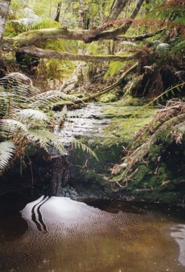
Cascade in the rainforest section of Monolith Valley - Photo: P Ellis
We descended into the valley via the Green Room, Brett showing us a second little canyon that is believed to be the rightful Green Room before heading up to explore the natural arch. The ascent onto the arch was probably the most difficult of the climbs we had to do during the whole walk, only because of the large rock that had to be scaled to reach the floor of the arch. Somehow Brett managed to get up and give us a hand scrambling up. "Brett Davis, You've Done It Again".
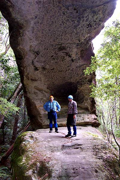
Paul & Gary on the Natural Arch near Monolith Valley - Photo: B Davis
There was nothing spectacular about the arch, but it did give us chance to take photographs of each other standing on the narrow rock. After photos were taken, we clambered down and continued on, stopping only to take photographs of the small cascade on the creek. We stopped at the small footbridge to collect water and took a short detour into Monolith Valley proper before starting the serious ascent to the top of Mt Owen.
First we had to cross a small ridge, scrambling over moss covered rocks and using tree roots for hand and footholds. There were also several rock slopes we had to scramble up too. Several times we were required to backtrack after taking the wrong ascent. Brett would often let us rest while he scouted ahead for the correct route, eventually finding a cairn and calling us through. There were a number of steep sections to be negotiated, again scrambling across ledges, using tree roots and at one time even the trunk of a tree to aid our ascent. Eventually we found ourselves on top of Mt Owen and we followed the cairned route across the top to the southern tip of the mountain. At the end we had to negotiate a deep gully and ascend to the southernmost tip where the visitors book is located.
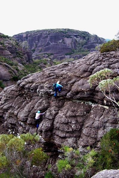
Paul & Gary during the ascent onto Mount Owen - Photo: B Davis
Here we had excellent views of The Castle, Mount Nibelung and Pigeonhouse Mountain, though a gum tree blocked our chances to use the camera. After signing the visitors book we descended part of the gully and made our way to a ledge for uninterrupted views where our cameras clicked happily away. We then returned to the gully to get out of the wind for lunch. It was a pity about the overcast conditions that gave a dull texture to all the views, but for myself and Gary, this was our first attempt at Mt Owen and we were quite satisfied with what views we had.
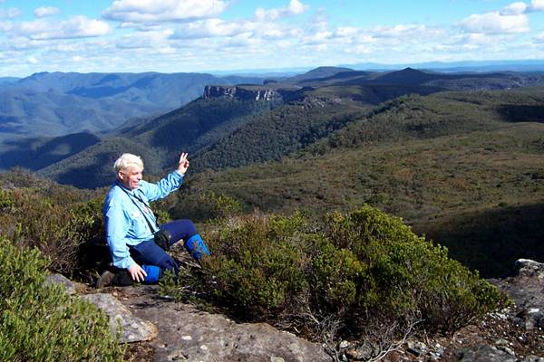
Gary on top of Mt Owen with the Castle as backdrop - Photo: P Ellis
At 1.00pm we headed back to the camping cave at Mt Cole. The wind picked up during the walk back across the summit, forcing us to don our rain jackets for extra warmth. When we reached the gully between Cole and Owen, Brett located the cairned route down the gully to the base of Mt Cole. This descent was reasonably easy with only one steep section down a sloping rock slab. We descended this on our backsides using a water eroded chute for extra stability. We passed a group coming the other way, incredulous at their attempt to do what we had done in reverse at such a late time in the day. We reached the bottom of the gully and made our way along the base of the cliffs to the camping cave at Mt Cole and retrieved our rucksacks. Gary and I gave Brett a hearty round of applause for his efforts in showing us a great day. At 2.30pm we saddled up and made our way to Bibbenluke camp.
Once at Bibbenluke we topped up our water supply. We had made the decision to reduce the trip to only 4 days. There were 3 main factors that governed this: 1. The cold windy weather had put a damper of our desire to explore Mt Tarn next morning. 2. We had done almost everything we had set out to do and see during this trip and more, and 3. Brett was keen to get home a day early so he could work on a presentation on computers he was doing on the Tuesday. We all agreed that 4 days was most sufficient. For us to get back to the car at Wog Wog by Sunday afternoon, we decided it would be much easier if we started the day from one of the camping caves at Burrumbeet Brook. We shouldered our packs and headed off across Bibbenluke Ridge.
The walk back to Burrumbeet Brook was freezing. Not only was the temperature very cold, but the wind picked up, adding to our discomfort. Along this stretch Brett powered ahead telling us he would stake the Burrumbeet Hilton for our use tonight. We would meet him there. There was no respite from the cold and wind as we descended to Burrumbeet. My back was playing up and to make matters worse I walked into a stubby branch from a bush that protruded onto the track, stabbing me painfully in the leg just millimetres from my groin. The pain was excruciating, but we only had about 100 metres to go before the track to the cave and I battled on grimly. It was 4.55pm when we joined Brett at the campsite.
We spent the next hour setting up our tents and preparing dinner. Brett rewarded us for showing him the location of this cave by collecting an impressive amount of firewood and we soon had a roaring fire going. Thankfully the cave was well sheltered from the windy conditions and the campsite was soon warm. After dark we could make out the glow of a campfire in a cave across the valley and felt sorry for the occupants who were obviously not as comfortable as ourselves. Our only discomfort was the Tuba Player noise coming from a nearby tree as its branches rubbed across the trunk of its neighbour. During the evening the sky cleared and we could again pick out the stars above us. We retired to our tents at 8.30pm.
Sunday morning found us up at 6.40am. All slept well, except for Gary who claimed the noises from my tent kept him up all night. I am pretty certain that the actual sounds came from the Tuba-playing tree. Today we would be returning to the car at Wog Wog by taking a new route - following the Corang River and Goodsell Creek area. We wasted little time packing up and it was 7.40 when we descended to the track. We made good time, arriving at the conglomerate slope at Corang within 20 minutes. We located the track to Canowie Brook and arrived there at 9.10, stopping only to fill up the now empty waterbag.
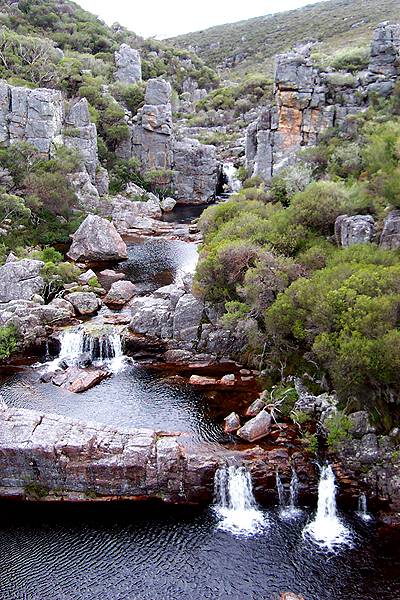
Cascades on the Corang River near the junction with Canowie Brook - Photo: B Davis
The track from here to the Junction of Canowie Brook and the Corang river was a difficult slog. Although there was a defined track, it was badly overgrown and the ascents and descents were quite taxing. We took a break on a rock high above the Corang, getting excellent views of 3 waterfalls. A defined track, marked by small rock cairns took us past a good campsite and across Broula Brook. From here we relied on Brett's navigation skills to get us to the campsite and cascades on the Corang River near where the track to Goodsell Creek starts. The country here is open scrub with no sign of any defined trail. He did the job most admirably and at 10.45 we arrived at a spacious campsite on the banks of the river.
We dropped our packs and went to explore the cascades. Cameras clicked as we crossed many rocks and viewed countless rapids. Near the end we passed a deep very cold looking pool that would make an excellent swimming hole in warmer weather. These cascades were certainly the highlight of the day. We returned to our rucksacks at the campsite and prepared to make our way out along the Goodsell Creek track.
It was great to be finally walking a well-defined walking trail after the scrub bashing efforts so far this morning, even though the first section was quite steep. We were soon walking on top of the ridge though. We descended and ascended both sides of several small tributary creeks before the big descent to Goodsell Creek and a break for lunch at 12.20pm. Brett located a very nice looking campsite just downstream from where we had our break - another to file away for future reference. We moved off again before the half hour was up, climbing up a slope of loose scree to the track above. This was the final and hardest ascent of the day. We crossed yet another small tributary creek and within minutes we had reached the main track to Wog Wog. We really put on the pace now as we climbed to Tinderry rocks and passed them without stopping. We continued without much ceremony along the ridge dropping to and crossing Wog Wog creek and the small climb out to the Wog Wog carpark, arriving there at 2.05pm and greeted by a few drops of rain, the first we had received all trip. I was most relieved to find I had not left my car headlights on, a worry that had dogged me for much of our walk today. We all agreed it had been an excellent four days of walking. No doubt a return trip will be on the cards sometime in the future.
BACK TO WOMBATS MAIN PAGE