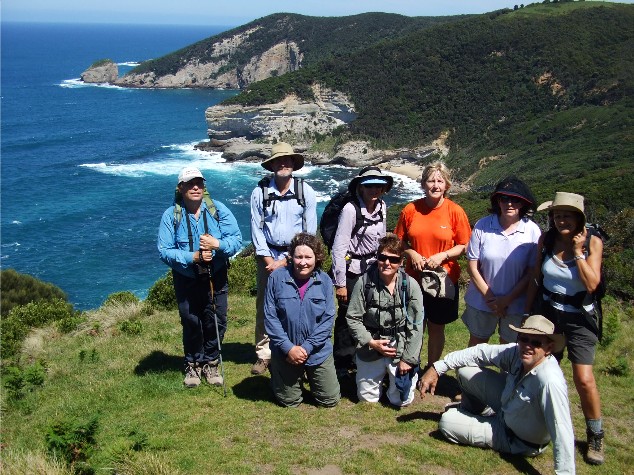
Victoria's Great Ocean Walk runs parallel to the Great Ocean Road between Apollo Bay and Port Campbell and is one of Australia's newest long distance walking routes. It commences in Apollo Bay and finished next to the now closed Glenample homestead near the 12 Apostles. Approximately 90 kilometres of track, sandy beaches and old forest roads are to be negotiated to complete this very scenic walk. Ten members of the Shoalhaven Bushwalkers made the long drive to Cape Otway in late October 2008 to walk the Great Ocean Track, however, we would not be walking this track as a full pack walk, camping overnight along the trail (as is often my preference) we would experiencing the walk as a series of one day walks utilising car shuffles from a base camp. We would have two groups of 5 walkers doing the track from opposite directions, hopefully meeting near the halfway point each day for lunch then heading for the other vehicle (the spare keys having been swapped prior to the walk) The people doing the walk, apart from myself, included Brett & Karen Davis, Doug & Gaynor Berthon, Sandra Kelley, Margaret Perkins, Pam Harcombe, Julie Davison and Mary Wilkinson.
Bimbi Park is a caravan and camping retreat in the forest, just off the Cape Otway Lighthouse Road which includes YHA style accommodation in the form of bunkhouses, cabins, powered caravan sites and camping sites. It is equipped with its own group kitchen & lounge room facility with coin operated barbecues, a shower & laundry block, Stables and shelters but the main attraction of Bimbi Park is its Koala population. Brett & Karen, Doug & Gaynor and I had chosen to pitch our tents in one of the many rustic camping areas. The other 5 girls had been booked into a cabin with the wonderful name of 'The Swamp'. Brett and I were to spend much of the week thinking up inventive meanings in this cabin's name. What does 'S.W.A.M.P.' stand for? We came up with many, but the best seemed to be Sexy Women After Meno Pause, Shoalhaven Women Adore Male Penetration and Shoalhaven Women Are Madly Paranoid. I found it more fun to address the 5 women as 'Swampies' whenever I greeted them. At around 5.30-6.00pm each evening we would gather for our in-camp Happy Hour, a regular event where we would discuss the next day's walk, where we would be parking the cars, whose vehicles would be used, what we might see and who would be forming each group. This was usually accompanied by the intake of copius amounts of alcohol and snack foods.
DAY 1: Marengo to Blanket Bay
The first morning of the walk was quite overcast and it looked like rain was threatening. Discussions the previous night revealed that the first 3km of the Great Ocean Walk west from Apollo Bay was along footpaths or the roadside, and although mainly a flat walk at sea level, it was considered a little mundane for the majority of our group . It was decided that the walk would start 3km in at Marengo, next to the caravan park. We also decided that the first four official days of the walk were very short in distance so our first two days would cover the official first four of the walk. Although this originally raised eyebrows as to walk difficulty, it turned out that even with full pack walking, a fit walker would find it very easy to walk these first four sections in two days.
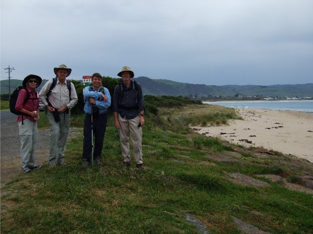
The start of our walk at Marengo. L-R Gaynor, Doug, Paul & Brett
I was in the group walking east to west (as was my preference for the entire walk). My companions today were Brett & Karen and Doug & Gaynor. The other group would commence their walk from Blanket Bay and finish at Marengo. By the time we had arrived, parked the car, put on our packs and had photographs taken to commemorate the start of the walk it was becoming quite a humid day and the flies were swarming around us as we headed through the Marengo Caravan Park along a yellow coloured crushed gravel pathway which we christened 'The Yellow Brick Road'. Views of a rock platform just off the coast on Marengo Reefs revealed our only view of seals for the entire trip.
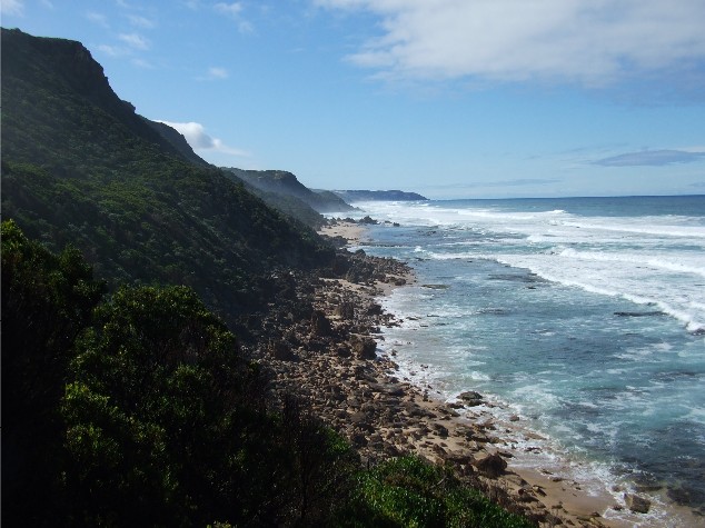
Once through the caravan park we passed what would soon become the familiar blue 'Great Ocean Walk' signposts, plus a yellow sign warning us of snakes as the narrow track took us through heathland behind a beach. The track eventually brought us out to the beach and onto a long rock platform, the weathered rocks resembling cobwebs with their pockmarked appearance. Our first major ascent of the trip was a short but steep climb up rock steps onto Bald Hill which gave us some excellent coastal views from the top. The descent down the other side was along a steep grassy slope. By now every walker's rucksack was covered in flies.
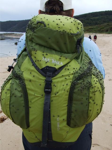
The flies were thick today
We followed more rock platform for a short distance before again ascending a track up a short woodland covered hill until we descended to the very tiny Shelley Beach. We decided to follow the rock platform along the coast rather than go back up to the track. The rock formations along this section of coastline were very impressive. The conglomerates provided shapes that resembled broken eggshells, mushroom style outcrops and one shape that resembled a toilet seat. It was along here we stopped for a tea break right next to an inlet that I thought may be the narrow mouth of the Elliot River. During our break it rained lightly, though not enough to have us rushing for our wet weather gear. If anything the misty rain kept the flies at bay while we nibbled.
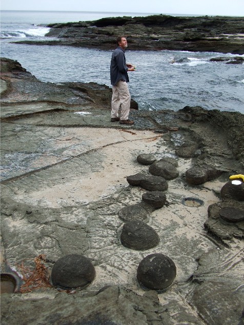
Brett at rock platform near Shelley Beach, checking out the formations
Locating the track behind us we crossed the inlet and followed a long steep track that now ascended into Stringybark Gum forest, sometimes referred to as Manna Gums and eventually arrived at the Elliot Ridge walk-in Campsite which was very impressive. We scouted around noting many numbered tent sites with square wooden benches that resembled tent platforms, a three sided wooden shelter, composting toilet block and two rain collecting water tanks. We later found that all the walk in campsites along the Great Ocean Walk were like this and once again I started wishing I was doing this walk as fullpack, if only to savour the camping areas on the walk. However, it wasn't even midday yet and we had reached the first overnight campsite on the walk. It was obvious we would have no trouble reaching Blanket Bay by mid afternoon. Scanning the trees above the campsite we noticed koalas high up in the branches, very high up. Obviously at night this place would become 'Party Central' as the track notes mentioned yellow bellied sugar gliders also reside here and no doubt a possum colony too.
The track now headed inland through rainforest and eucalypt forest, following the unsealed Elliot River Road. The forest was full of bird song which had Brett & Karen stopping many times and scanning the trees with their binoculars, hoping to spot yet another rare bird species. Just before midday we rounded a bend in the track and came face to face with our 5 other walkers who had walked in from Blanket Bay. We stopped to chat about the track conditions facing each group and then headed off. We were warned about very muddy conditions ahead and it wasn't long before we were stepping around the edge of some deep mire in the track. We also noticed several cone-like structures made from mud that had obviously been built by some animal. We later learned these were the burrows of land yabbies.
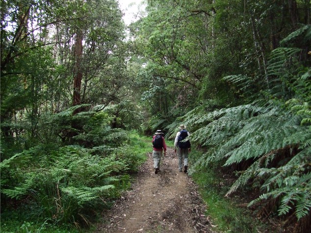
Gaynor & Doug negotiating forest path after ascending to Elliot Ridge
The track now seemed to be ascending again and the rain appeared once more, once again not heavy enough for us to don wet weather gear. We came to a bend in the track, next to which was a pile of fallen tree logs and decided this would make a suitable spot for lunch, though not as comfortable as our other group who got to utilise the shelter at Elliot Ridge campsite. Moving on our track soon reached an intersection and we turned left onto Parker Road as we crossed Parker Spur. Another intersection about one kilometre further on had us turning left again onto Johnsons Track which saw the commencement of our descent to Blanket Bay. This started out as a gradual descent through more forest until the intersection with Telegraph Track.
This narrower track descended a little steeper and Doug found himself in the lead until we saw several snakes on the track. These snakes were dark brown and had a greenish coloured belly. We later learned these were Copperheads. Doug soon had me walking in front on what he called 'Snake Patrol' though I never saw any snakes while I was in front, maybe it was my heavy bushwalking boots alerting the reptiles to my oncoming presence. The track now descended very steeply to the beach at Blanket Bay and I really felt for our other group who had to climb up this. Strangely they were thinking the same about us as they descended Elliot Ridge back to Shelley Beach. We stepped out onto the beach at Blanket Bay and made our way to the Drive In Campsite where the car was waiting for us. We had a quick look around the site before driving back to Bimbi Park for a well earned shower and change of clothes.
DAY 2: Blanket Bay To Aire River
Monday October 27th 2008. I awoke at 7.00am after a very comfortable night's sleep. The new pillow and the fact I had no luggage in the tent made for a very relaxing sleep. I didn't even hear the brawling koalas. Sadly, again the skies were overcast with rain again threatening. I made my way up to 'The Swamp' to collect my rucksack and organise my food for today's walk. After yesterday's problems with my boots I decided to do today's walk in my joggers as my ankles were still very sore. A decision I later regretted as my new joggers were quickly ruined by the sharp scrub of today's walk.
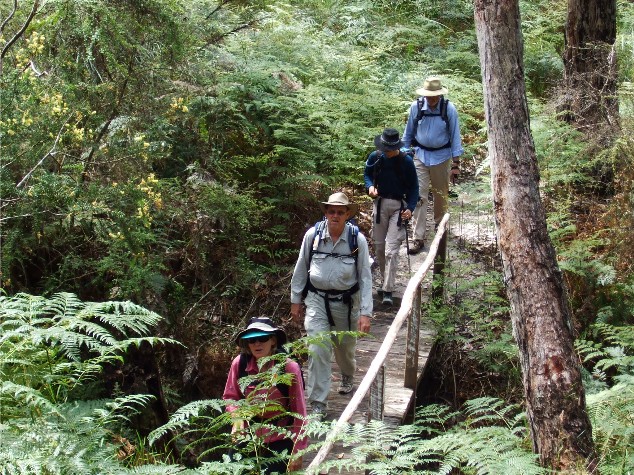
I found myself in a car driving to Blanket Bay campsite, the skies were overcast with rain again threatening.. Once again I would be walking the east to west route and today my walking companions included Doug & Gaynor, Mary and Margaret. It was our walk leader's hope that everyone would eventually get the chance to walk together if the groups were shuffled. Our walk commenced where we finished yesterday, right next to a boot cleaning station. There are several of these located along the Great Ocean Walk and walkers are expected to brush their boots to remove fungal spores that can spread die back in plant communities along the track. These 'Hygiene' Stations come equipped with a seat and brushes. We then headed out along the boardwalk behind the beach.
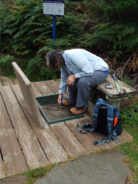
Margaret cleans her boots at Blanket Bay's Hygeine Station
The boardwalk only went for about 100 metres before becoming a bush track that ascended into forest. The track went inland for some distance and we caught up to a lone bushwalker who is doing the Great Ocean Walk as a full pack multi day hike and I envied him immediately. He was one of very few other walkers we would meet on the track during our 5 days of walking. We now descended to the sand at Parker Inlet, crossed the shallow channel and were then forced to make a decision. We had a choice, continue following the coastline via the beaches and rock platforms around Point Franklin, or ascend the steep hill and walk the cliff tops. As we could not see around the headland to assess the tides and the walk to the headland was reasonably long, we decided to take the inland option. We quickly found ourselves climbing a steep ascent where the track had been constructed with stone blocks to create steps. It was quite tiring, but not too hard. Eventually we reached the top where the track levelled out, providing excellent views, and made its way along the cliff top heathland. Once again I was put on Snake Patrol, but immediately sacked after Margaret and I passed a large Tiger Snake sitting on the side of the track. We basically stepped past or over it without realising, leaving those at the rear to deal with a rather agitated serpent.
Looking down onto Parker Inlet from the top of the rock steps
To make matters worse, as we came over a small rise and noticed the Cape Otway Lighthouse in the distance, we could see the weather taking a change for the worse. Our wet weather gear was going to get used today. We arrived at a track intersection and located a grassy clearing above the beach to take a break and put on our raincoats just as the rain hit us. We cut short our tea break and followed the new track away from the coastline. This track resembled the 'Yellow Brick Road' we had walked yesterday as it passed a small car park. Eventually, after one kilometre we turned left at an intersection and through a gate, turned left immediately and followed this trail for a short distance. It came out onto the bitumen of Cape Otway Lighthouse Road, not far from Bimbi Park and we continued walking up this road for at least 2km. We didn't know it at the time, but with our heads down, averting the wind driven rain from our faces, we missed a signpost immediately on the right hand side of the road that marked a parallel foot track that would have kept us off the bitumen and away from the onrush of tourist vehicles. Instead we battled on grimly until we finally arrived at the Cape Otway Lighthouse Complex. We immediately headed for the shelter to get out of the rain.
We were all very keen to visit the lighthouse and perhaps even photograph it, but we were all astounded to learn that we had to pay an exorbitant fee of $14.50 each just to get into the grounds. We settled for a cold drink from the ticket office which also doubled as a souvenir shop. Whilst enjoying our drinks our lone hiker arrived. His day was almost over, the Cape Otway hike-in campsite just 5 minutes away. We arrived at the campsite at exactly the same time as the other walking group who started from the Aire River this morning. We all made our way to the three sided shelter and got out of our wet parkas and found enough room for the 10 of us to enjoy a long lunch break. The only news the other group had for us was that the track near the Aire River was very sandy and we should also consider taking the cliff top track this afternoon rather than the beach track.
Our groups split up after lunch and with a minor break in the weather we were able to stop and look around the old lighthouse cemetery before taking the cliff top track to Aire River. We passed by the track intersection to Rainbow Falls, the return of the wet weather dampening our enthusiasm for taking a short side trip. To add to our discomfort a strong wind had come up and apart from blowing the rain at us it also was strong enough to almost knock us over along the areas unprotected by tall trees. I was glad the wind was coming from the direction of the open cliff tops or the walk could really have been interesting.
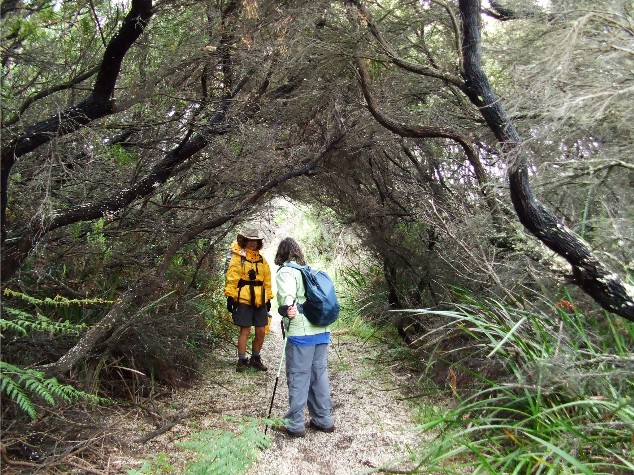
Mary & Margaret in the tunnel-like Melaleuca forest near Aire River
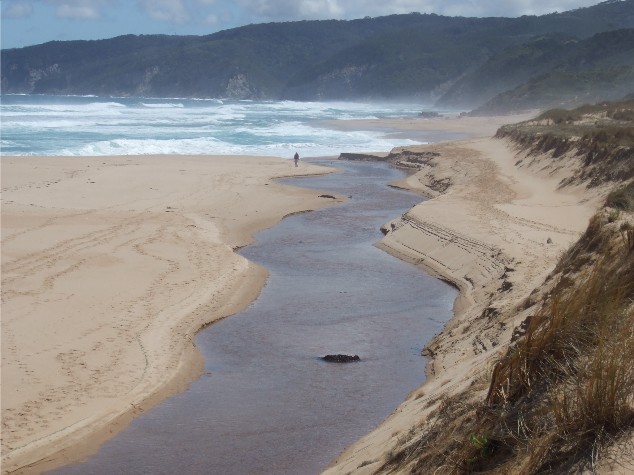
We started to notice some very interesting snails on the track too and we had to watch where we were putting our feet or the bush would have resounded with the sounds of "Crunch Crunch Crunch" as we walked. After reaching a spot where we could look down onto the mouth of the Aire River we followed a very sandy track that descended through tunnel-like thickets of Melaleuca. I think we certainly found descending through the thick sand much easier than ascending and we felt for the other group and the tough track they had battled this morning. We followed another very sandy track to the famous Aire River Bridge (seen in most books, pamphlets and websites that feature the Great Ocean Walk) I couldnít resist taking my version of the ultimate Aire River Bridge photograph as everyone crossed. We crossed the bridge in the rain and on the other side was a small track to the car park where Doug's car was waiting for us, just below the walk-in campsite.
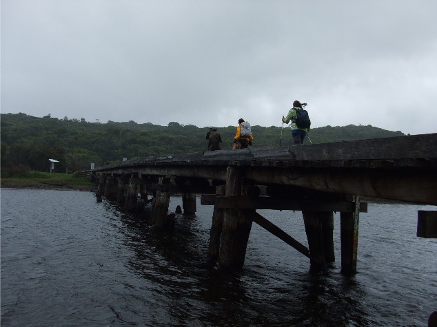
Crossing the Aire River Bridge in miserable conditions
DAY 3: Aire River to Johanna Beach
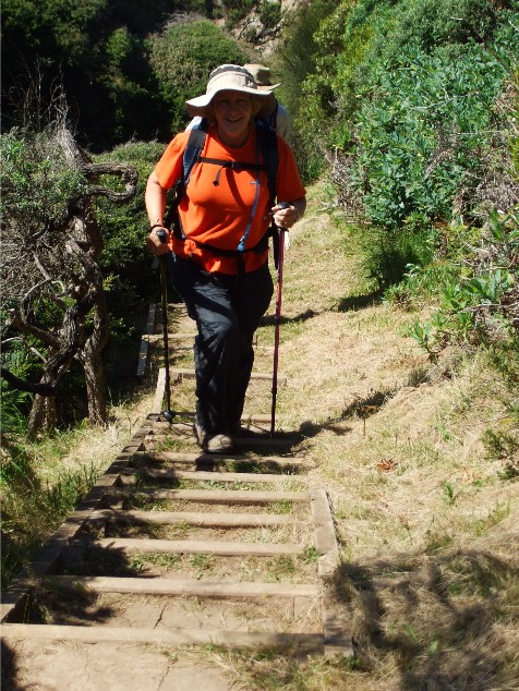
Today we would be tackling the steepest and highest section of the track at the finish of our walk, according to the guide map, the horrendous climb up the ridge from Johanna Beach. I contemplated this as we drove to our starting point. 25 minutes later we had parked the car and I realised to my frustration that I'd left my trekking pole behind at the campsite. Leaving trekking poles behind was becoming a habit, yesterday it was Margaret, today me. I would spend most of the day searching for a decent length of dead wood to substitute but sadly Melaleuca forest does not provide the strongest or straightest of timber and I found myself constantly changing the staffs when a better looking one appeared. Suffice to say that when we reached the car at day's end I had found a very nice strong and straight piece of timber that ended up being thrown back into the scrub.
Today's groups were identical to the first day's. I was again walking with Brett & Karen and Doug & Gaynor. With the clouds clearing overhead to reveal a wonderful blue colour we set off along the track from Aire River and walked through the 'Walk-In Campsite' and ascended a ridge through coastal melaleuca and heathland until the track levelled out. As the track met up with the coastline again, it now descended to a spot halfway up the ridge above the waterline and kept to this basic contour for quite some distance. The track was narrow and sandy but very scenic as we had the rugged cliff tops above us and the rock platform and sand below. I noticed there were a number of black and white coloured butterflies on the track and one fluttered around me for quite some distance. It was also becoming quite warm as the sky cleared and the sun shone down on us, a nice change from yesterday.
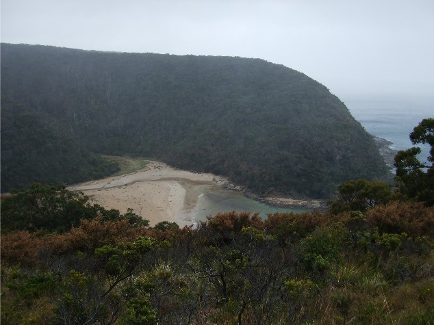
Looking eastwards along the coastline from near Castle Cove
We arrived at Castle Cove, noting the eroded rock formations across the bay. We were only one headland around the corner from the famous Dinosaur Cove, but sadly we wouldn't be visiting this place on the walk. Castle Cove is at Glenaire where the Great Ocean Road meets the water along this section. Our plans for coffee at the famous Glenaire Cafe were thwarted when we realised it was closed. Instead we sat on the grass next to the lookout and mingled with the tourists while we enjoyed morning tea. We also noticed the flies were getting quite thick in numbers as the temperatures rose. We now followed a high track through the scrub at the top of the cliffs that meandered around the headland, giving us excellent views of the eroded rock pinnacle. We were also treading very carefully as we were again walking in tiger snake territory. The most dominant plant species along this section of track seemed to be Xanthorreas (Black Boys/Grass Trees/Kangaroo Tails) their long stalks all in flower. Brett & Karen were slowed down along this section due to the large number of birds in the nearby trees. The track now descended into a deep forested gully still flanked by many flowering Xanthorrea stalks. We crossed a small wooden bridge over a small creek then started the ascent to the top of the ridge above Dinosaur Cove.
Crossing the creek Gaynor, Doug, Karen & Brett
When I reached the top I discovered another boot cleaning station. After cleaning my boots I followed a long wooden boardwalk across the hill top and as I arrived at the boardwalk's end where the 2nd cleaning station is situated, there was our second group. Once again we were passing each other much earlier than expected, it was nowhere near lunchtime. All this group could do was warn us about the masses of flies near the walk's end. They were bad enough now and I was very thankful to have bought along my head mesh which I was now wearing to keep the flies at bay and it was working quite well.
Moving on we followed another coastal track which descended to the sand at Johanna Beach, so named after the wreck of the Johanna off this beach in the 1800's. We walked 50 metres up the beach where Brett & Karen decided we would sit in the sand just in front of the dunes and have lunch. After which we struggled along the soft sand of Johanna Beach, a good 2km in length until we reached another obstacle, this being the fast running and relatively deep Black Witch Creek. While Karen and I took our footwear off, rolled up our trousers and crossed to the other side, Brett, Doug and Gaynor followed the creek all the way to the mouth at the waters edge, looking for a shallower crossing. On the other side Karen dried her feet and put her socks and boots on while I was content to walk barefoot for a while. We now ascended some high dunes and followed the line of Black Witch Creek to the mouth where we noticed that Brett & Gaynor had removed their footwear and had crossed over, though Doug risked wet boots.
Black Witch Creek snakes its way down Johanna Beach - Brett contemplating crossing near the mouth
We had another long section of sand to cross before we finally reached a track going behind the beach onto a soft green patch of grass next to the car park. Here I was able to remove the caked sand from my feet and put on my boots. We now faced the ascent from hell, something we weren't looking forward to after 2km of heavy sand walking and we were all quite surprised. It wasn't that bad at all, certainly not as bad as the brochure described. The track climbed steadily through gated farmlands giving us great views of the coastline on one side and lush green farmland valleys on the other. The flies were a menace and swarmed thicker the higher we went. We passed the 'Walk-In Campsite' and continued upwards. The blue skies also closed out and with deep dark clouds, threatened rain as we moved on higher. As we passed through the 5th gate we came upon an unexpected sight, Doug's car. The other group, obviously feeling sorry for the steep ascent we would be faced with decided to drive the car as far as they could down the ascent and got halfway down the 6km dirt track before the road got too rough. It certainly cut out 3km of boring road for us, but deep down we think we were cheated of completing the full length of the walk, though with all the flies swarming around us and the oncoming dark clouds looming we didn't complain at the time.
DAY 4: Coach Road Intersection to Wattle Hill
The sun was shining as we drove out to the intersection of the Old Coach Road and Melanesia Road. This intersection was supposed to have been where we finished our walk yesterday, but for the kindness of the other group who decided to move the car closer for us. We wasted little time in putting on our packs and heading off. My group today included Doug, Julie, Pam and Margaret. Margaret and I making sure we had our trekking poles today. We followed an unsealed gravel road for some distance as it passed by farmhouses. We noticed a strange looking structure at one side of a property that resembled a green flying saucer and which turned out to be a storage shed. A little further on we passed a roadside display that featured postcards, Jams and wooden staffs (this could have been useful yesterday) for a simple donation. The road now descended quite steeply to meet up with a hut at Melanesia Beach. We crossed the sand noticing the conglomerate patterns in the cliff face. It resembled Chocolate Chip Ice Cream. We ignored the Decision Point to go around the beach as the tide wasn't quite in yet, though it was close enough.
As we made our way across the rocks, picking our moment to cross the wet sand between the onrushing waves. Safely around the point and onto the second stretch of beach we located a rocky spot to sit and have a tea break. We were then faced with quite a climb. Beside the beach was a stepped track which ascended to meet the alternate behind the beach route. This then ascended after crossing a wooden bridge using wooden steps. The track then climbed steeply to come out on the cliff side, still ascending and providing magnificent views of the coastline before another set of steps took us high over an outcrop of rock at Bowker Point then descended into a small gully. The track gradually descended along a forested cliff edge, one section utilising a wooden set of stairs after which we passed some very photogenic trigger plants. The track then commenced ascending once again and firstly we were faced with about eight flights of wooden stairs, complete with banisters. I couldn't resist the urge to blurt out "3rd floor Ladies underwear, 4th floor Haberdashery, 5th floor Men's suits" as we made our way up each flight. much to the amusement of Pam and Margaret.
Pam negotiates the steps from Melanesia Beach onto the ridge track to Ryans Den
After the impressive 8 flights of wooden stairs we were faced with a steep zig zagging track. The occasional gap in the forest provided a cool refreshing breeze which was welcomed gratefully by all of us. Eventually, as I rounded a bend in one of the zig zags I noticed a strange and familiar roof shape high above. I knew this shape well as all the shelters on the Great Ocean Walk Campsites had these roofs. We were quite close to Ryans Den campsite. As we neared the top of the ascent Julie called down to us, telling us to head to our left and through the campsite.
We passed through Ryans Den campsite noting the familiar set up we'd seen so far on the walk until we reached a track heading up a steep hill. At the top was an open grassy area complete with wooden platform and excellent views up and down the coast. The other group was here too and we celebrated the crossover by organising another group photograph with the impressive Cape Volney in the background. As the other group had only recently had morning tea they headed off, hoping to reach Melanesia Beach for their break. Our group commenced lunch, though both Margaret and I weren't hungry so we agreed to move on to where the other group had stopped for morning tea. We would take lunch there and wait for the others to catch up. Brett had pointed out the spot as being on a grassy hill in the distance. We had more ascending to do.
Our group at Ryans Den camp with Cape Volney forming an impressive backdrop
Back Row L-R Paul, Brett, Gaynor, Pam, Margaret & Mary - Front
Julie, Sandra & Doug
Margaret and I headed off, ascending through forest, crossing another creek via a wooden bridge and then ascending onto the bottom of the grassy hill. Breathlessly we made our way to the top where we discovered a wooden bench. We dropped our packs and got out our lunch. The cool breeze was most refreshing here and the views were still very good from this vantage point. Margaret handed me her binoculars so I could check back to Ryans Den. Through the glasses I easily picked out the platform on top of the open hill, but there was no sign of the others, they were already on their way. Just as I finished eating they appeared at the bottom of the hill. After lunch the track continued to ascend and descend through coastal heathland and it was quite hot going. At one point along a narrow grassy section of track Doug leaped into the air, jumping several metres as he almost stepped on another snake, the snake struck out at him and he barely avoided getting bitten. This snake appeared to be rather small with a yellow belly, but the stripes on its back left no doubt that it was a tiger snake. At first we thought it was a juvenile, but speaking to the local tour guide back at camp later we were informed it was a fully grown adult and a very aggressive one. As I passed the point where Doug had almost stepped on the snake I noticed it was still sitting in the grass just a metre from the track ready to strike. The rest of us wasted little time in getting past. Our eyes would be glued to the track for the remainder of the day.
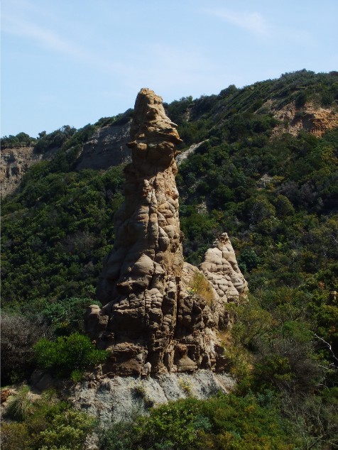
Impressive looking pinnacle near Moonlight Head
The track continued to ascend through the scrub and we wondered when we would reach the road at Wattle Hill. We passed a very photogenic pinnacle in the bush and stopped to photograph this. At the top of the hill above Moonlight Head were two benches which we sat on and enjoyed a very cold breeze coming off the ocean. It was so refreshing after the heat of the ascent that we could have sat there for the remainder of the afternoon. We scrambled over a stile and stepped onto a dirt road near the Moonlight Retreat B&B. We now had a very demanding 4km walk along this road through forest and farmland to Wattle Hill where the car was parked at the track intersection.
DAY 5: Wattle Hill to Glenample Homestead
We set off for Wattle Hill under overcast weather. All 10 of us would be walking the same direction today, this was due to the fact that everyone wanted to visit Wreck Beach with its historic anchors before the high tide at Midday. After dropping off the main group, the drivers would take the cars to Princetown, the finishing point for today's walk, then drive back with one vehicle to join the rest of the walking group. We walked down the unsealed Moonlight Head Road and arrived at the intersection for the alternate high tide route 10 minutes before the shuffle vehicle arrived with all the drivers. We took this opportunity for a quick break. Once everyone was together we continued on towards Wreck Beach. We passed by Moonlight Head Cemetery and stopped to view some of the historical headstones before making our way onto a narrow track and on to Gables Lookout.
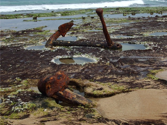
Anchors and Capstan of the Marie Gabrielle on the rock platform of Wreck Beach
Gables Lookout is a wooden platform standing on top a high cliff. The cliff viewed from the sea looks like a roof gable, obviously giving the lookout its name. We then back-tracked to a narrow side track and followed this through the bush before the track descended steeply to Wreck Beach. Just as I stepped out onto the beach it commenced raining, though only lightly and not for long, but the cloud cover still made things very dark. We now made our way across the sand to the rock platform where two anchors lay embedded and rusting in the rock. These two anchors and a capstan are from the wreck of the 'Marie Gabrielle'. Further on, cemented into the rock at the back of the beach is an anchor from the wreck of the 'Fiji', both ships foundering during the late 1800's. No wonder they call this the 'Shipwreck Coast'. After scrambling over a jumble of rocks we made our way to the track head on the western end of the beach. Locating the track we followed it as it ascended through the cliff line to Devils Kitchen not far from the 'Walk-In Campsite'. We now followed the Old Coach Road to Princetown and this became a tedious and totally boring section of walk. The track was wide and very sandy and there was very little to see in the way of views. We descended to the Gellibrand River and Princetown Beach but ignored side tracks, preferring to get the sandy tracks behind us. We were most thankful when we stepped onto a firm dirt road and crossed the Gellibrand River bridge.
On the other side of the bridge was a long grassy area complete with picnic tables. It was early afternoon and the day's finish was only 100 metres up a dirt road. Across the boardwalked swamp we could see our vehicles parked up on the hill. Our leader Karen made a quick decision. She offered everyone the chance to complete the final 5.5km walk today, rather than drive all the way back tomorrow. We all agreed to complete the walk from Princetown to Glenample Homestead. When we got to the trackhead at the intersection of the Old Coach Road and Great Ocean Road south of Princetown, I wondered why everyone was waiting around. It soon became obvious that many of the group were waiting for our vehicles to arrive as they are shuttled to the finish point so they could drop off their rucksacks for the final stretch of walking track. Doug, Julie and Mary had already set off along the track and I decided to follow. Considering the sky was now clearing and it was becoming quite hot there was no way I was walking without water. I informed our leader I was heading off and set out on the final stretch of The Great Ocean Walk.
Almost immediately I was annoyed as I found myself on another wide and very sandy trail, but not long after I passed Mary on the trail I noticed a signposted side track heading into the heathland. This narrow track ascended and descended along the cliff top as the track made its way west and I soon caught up to Doug and Julie as they stopped to get their first views of the distant 12 Apostles from a high knoll. They continued on as I enjoyed the views. I was careful to watch out for more snakes, though I didn't see any during this last section. The walk was becoming quite hot and I was glad I'd kept hold of my rucksack with its hydration system. I stopped for a short break to grab a drink, hoping the main group would catch up to me, but only Mary appeared over the horizon to the east. I waited for her to catch up and she asked me if I knew how close I was to the finish. I told her I thought we had only walked 4km of the 5.5km distance. However, as we came over the next ridge I was surprised to see the track descending to a car park on the side of the road. Opposite the road was the now closed Glenample Homestead. We were in sight of the finish line. As I looked back to the east I noticed the other group coming over the hill. Mary and I descended the steps to the car park and the finish of the walk.
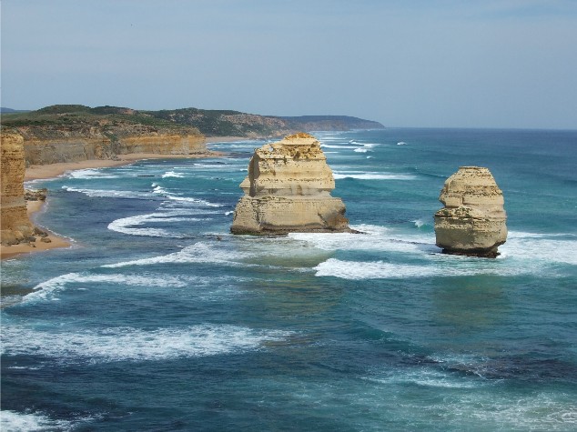
Two of the famous 12 Apostles from near the end of the Great Ocean Walk
Once everyone else arrived and caught their collective breaths, it was decided we would drive up to the 12 Apostles and Loch Ard Gorge to take a closer look at the rocky pinnacles. After which we would then drive into Port Campbell to have a celebratory drink at the local pub. We arrived back at Bimbi Park at 7.30pm. Within one hour everyone was present in The Swamp enjoying more celebratory drinks to finish off a great 5 days of bushwalking.
Return To Wombats Home