This section of the Hume & Hovell Walking Track was the final walk we did during our stay at Laurel Hill in 2008. We had walked a section of the track on the first day, but this was only around 30% of the walk. Henry Angel Trackhead is just 7km south of Tumbarumba on the Tooma Road and contains a suitable car park area, camping sites, toilet block and information building. Again Lauri Ball was leading this walk.
Some of our group decided they wanted to walk the section of track north to Junction Campsite, while the majority of us decided to follow Lauri southwards. It certainly ended up being the best walk of the week. Following the Hume & Hovell Track signs we exited the camping area and walked out onto the Tooma Road, almost immediately crossing and climbing over a fence via a stile. There would be many of these today as we passed through sections of private property on the track.
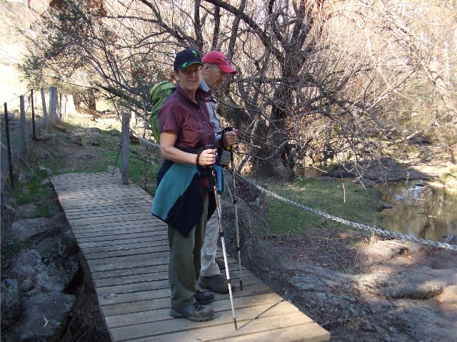
Tony & Bev Simmonds on a boardwalk on the Hume & Hovell Walking Track alongside Burra Creek
The track follows the course of Burra Creek all the way to its confluence with Tumbarumba Creek. A return walk of 12km (including a side trip) and we quickly learned that this creek was extensively mined during the late 19th and early 20th Century. We would pass by old alluvial workings which included pilings, water races, weirs and an old 70 metre long tunnel which diverted the original creek. The track is well defined as it follows the creek with small bridges and boardwalks placed over hazards. The only downside was the incessant racket from the sulphur crested cockatoos as they constantly screeched overhead - a noise that would be our companion for much of today's walk.
As we passed by a section of Burra Creek that follows a bank of rocks built along the edge to sluice the gold workings. We soon looked down onto a bridge over the creek which we obviously needed to cross. We made our way across and followed the track on the other side. Soon we came to a fenced area, complete with stiles, but it was the platform on the other side of the creek that caught our attention. A small track took us around to the other side of the creek where the platform revealed a tunnel, dynamited through the rock many years ago by the gold miners, for sluicing purposes.
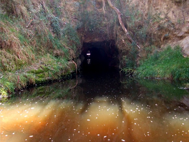
The man made tunnel on Burra Creek. The creek used to come in from the right
After taking a number of photographs we negotiated the stiles across the private property. On the other side we found a track that led to the creek. Once at creek level we realised we were looking at the same dynamited tunnel we had viewed at the other end, in fact, from the right angle at the water's edge you could see the entrance on the other side, 70 metres away. We now continued to follow the trail along the creek, following minor cascades through the gold workings. Eventually, we reached a series of rapids that were marked with a signpost declaring that Hamilton Hume & William Hovell and party arrived at this point on November 8th 1824 and Hovell noted the cascades in his journal. It was a good spot to drop packs and enjoy morning tea. I explored the area trying to get the best possible photograph of the cascades.
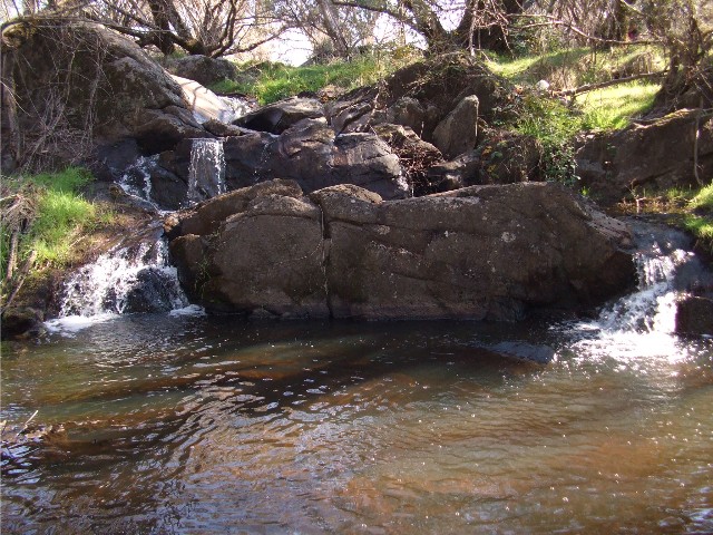
The Cascades on Burra Creek where we stopped for morning tea
The track continued to follow the creek, though a little higher up on the ridge line. Up here we were forever dealing with fallen timber (which Tony Simmonds despatched into the creek gully) or making our way across black ant hills. Eventually the track moved higher above the creek, this area was dominated by blackberry bushes, the most I'd seen in the wilds since the 'Six Foot Track' near Katoomba in 1988. Sadly the berries were out of season.
Eventually we reached a turnoff to the 'Big Hill' lookout, just 500 metre climb from the track. As we had just enjoyed morning tea, it felt too early to be stopping for lunch. I suggested to Lauri that I lead a group the 1.3km length to Tumbarumba Creek where we could sign the visitors book there. By the time we returned it would be a more suitable lunch time. Lauri agreed to split the group into two groups. I led the second group as we descended the ridge all the way to Tumbarumba Creek, finally arriving at the wooden bridge and crossing to the other side where those in our party signed the visitors book we found in a plastic tube next to the track marker.
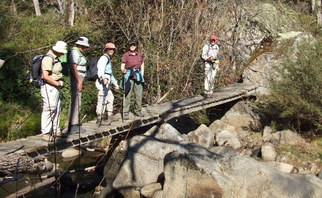
A group of Shoalhaven Bushwalkers on the footbridge crossing Tumbarumba Creek
Once everyone had signed we now returned uphill to the intersection to the 'Big Hill' lookout. By now it was well after midday and with little wind the going was quite warm during the steep climb back up the ridge. We took it nice and easy, allowing everyone to take their time and complete the ascent at their own comfortable pace. I soon caught up to Tony & Bev who had started the ascent earlier and continued to keep to their pace as we finally reached the track junction. The track now ascended quite steeply for 500 metres to a lookout somewhere above. The track was well marked with 'Hume & Hovell' track markers and there was a defined trail, despite there being other side trails running off at different angles.
Eventually we arrived at the lookout, a set of seats in an open area below Big Hill, but the important part of this location was that this is the place where Hume & Hovell first sighted the Australian Alps during their exploratory walk in 1824. The spot is marked with a signpost and we could look eastwards towards the alps, picking out Mt Townshend and Mt Kosciuzsko in the distance, albeit shrouded in mist. It would have been nice to have had a clearer view. We enjoyed our packed lunch whilst taking in these views. My very first sighting of Kosciuzsko.
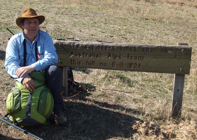
Me at Big Hill Lookout where Hume & Hovell first saw Mt Kosciuszko
When we decided it was time to head back, following the same track we had walked in on I discovered that during lunch where our bodies had taken the opportunity to cool down, that my knees,, especially the right knee, was starting to play up, jarring on every step during the descent back to the main track. I found myself falling behind the lead group as I gingerly used my trekking pole to ease my way along the descent. For company I had Ann Holwell, who also suffered from knee problems and we discussed the track and bushwalking in general as we made our way north. I found though, that as time went on and my joints warmed up from the exercise, the pain in my knee subsided and I soon managed to catch up to the lead group.
The remainder of the walk back to Henry Angel Trackhead
found me in the lead group (I would pay for this as I cooled down later
and my knee started to scream at me) but for now I enjoyed the views of
the cascades and mine workings as we headed northwards. Only a lone cow
challenged us as we crossed farmland near the Tooma Road, it's udder revealing
only then it was a cow and not a bull, but we had a few moments of worry
as it challenged us to pass before running into the cover of nearby trees
and watched suspiciously as our group passed by. Eventually we reached
the road and made our way back to the cars for an end to what was an extremely
enjoyably day walk along the Hume & Hovell track.