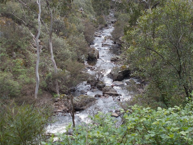
Micalong Creek from the track
On Thursday 2nd November 2017 I joined up with six other members of the Canberra Bushwalkers for a short walk along a section of the Hume And Hovell Walking Track near Tumut. The walk was led by Phillip Starr, a long serving member of the club. At 7.30am on a clear sunny morning we all arrived at the designated meeting place at Cooleman Court in the Canberra suburb of Weston. Apart from Phillip, I was only familiar with one other person in the group and that was Johnny Evans who is probably the one Canberra Bushwalker I have walked with more than any other since I joined in 2009.
To get to our walk starting point we had a very long drive out of Canberra along the unsealed and treacherous Brindabella Road. After almost 80km of driving, the road temporarily became sealed bitumen as it descended to cross Micalong Creek bridge. It was 9.15am as the cars drove down a fire trail towards Bondo State Forest. We passed a picnic area where some of the group utilised the toilet there before we drove another kilometre to a junction on the road and parked. We put on our rucksacks and headed north, almost immediately coming across a Hume And Hovell Walking Track guide post. We continued northwards following the forest road with Micalong Creek flowing quite fast down the slope to our left. We soon came to another HHWT post to our left and we left the road behind us as we set off along a well defined foot track.
The views of Micalong Creek below us were spectacular as the creek descended northwards in a series of major cascades and waterfalls. We all snapped photographs with a differing array of cameras and mobile phones. The noise from this rushing water drowned out the noise from the many bird species in the area that were in fine song this morning, when we could hear them over the noise of the cascading water. Two Yellow Tailed Black Cockatoos revealed their presence in the tree branches above us as we descended gradually to meet the creek. As with much of the Hume and Hovell Walking Track, Blackberry vines grew in abundance here on the trackside and their prickly brambles grabbed at our clothing as we passed by. Being late spring, the wildflowers were out and we were treated to vivid colours of pink, purple and yellow as we passed by such plants as the Handsome Flat Pea, Cassinea, Leafy Bossiaea and Royal Grevillea.
Micalong Creek from the track
We descended to a forest road where it crosses the creek via a shallow ford. We ignored this trail and continued on the track on the other side still descending gradually beside the creek until we arrived at a wooden bridge crossing. This bridge looked old and did not look safe. Made from two log supports, the narrow planks were simply rotting away with several missing in the middle of the bridge. The steel wire hand rail has half been pulled away and part of the bridge is tilting at a small angle. What appeared to be keeping the planks together was a roll of chicken wire which also looked like it was ready to roll away off the bridge during the next flood. It is obvious this bridge was damaged during the 2011 floods which destroyed many bridges on the track elsewhere on the trail. Slowly the authorities are getting these replaced as funds become available.
It was decided that we would cross the bridge carefully and one at a time. I was 3rd in line to cross and as soon as I stepped onto the bridge my boot got caught in the loose chicken wire. I did make it safely across though, but it was a bit nerve wracking just the same. I caught a photo of Johnny Evans crossing once I had reached the safety of the far bank. A sign on the other side revealed that this area was under review. I'm hoping this bridge will be repaired before I set off on the full walk of this track next year, though that is optimistic at the very best.
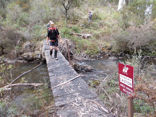
Johnny Evans crossing the damaged footbridge
Phillip suggested we bush bash to a set of rocks on the bend of the creek just 20 metres from the bridge where we could enjoy morning tea. We found the rocks quite suitable and the view of the rushing water just feet away quite enjoyable. The view under the bridge had us wondering how we had made it across safety and thoughts came to having to come back this way later on and attempt to cross again.
We continued on northwards, now on the western bank of Micalong Creek. The track was narrow and high above the creek, following a cut contour, but it did provide some very nice views of the Micalong as it descended through the valley northwards. We passed through an area of ferns that had obviously seen track maintenance recently. We crossed another footbridge, this much smaller and lower as it crossed Yankee Neds Creek before it joined the Micalong. We wondered who Yankee Ned may have been and came to the conclusion he was an American gold miner who joined the Australian gold rush in this area during the late 1800's.
Soon after, we reach another fire trail, marked with another HHWT post. We turn right and follow this trail north for about one kilometre until we reach Micalong Creek Campsite at 11.05am. Micalong Creek Campsite is a small camping area but it has the fast flowing Micalong Creek running beside it so no water tank is required. A rock platform provides a scenic spot with which to enjoy an early lunch and watch the creek flow north. The site also provides a wood fire barbecue, covered and uncovered picnic tables - the later having been vandalised - and a drop toilet. We call for an early lunch with an option.
Lunch on the rock platform on Micalong Creek at Micalong Camp
The option is to have a short lunch here, then continue northwards to another nice spot where the remainder of our lunch can be eaten, or, return to the cars and have a second lunch at Bossawa (Barrois) Campsite, before taking a walk to Micalong Swamp and its boardwalks to the south. I quite liked the latter scenario and it was agreed upon. At 11.40am we again put our packs on and made our return to the cars following the same route we had walked in on.
The walk back was quite pleasant and then we had the log bridge to cross. Again my boots got caught in the chicken wire, this time at the opposite end of the bridge, but I crossed safely. As each of us crossed, one by one much discussion was had about how long it would take to get the bridge repaired or replaced. A spot near where we had morning tea provided a suitable crossing point, though some negotiating of vegetation would be required.
We now ascended back to the cars, again enjoying views of cascades and falls as we took short breaks to catch our breaths. The steep incline wasn't that noticeable coming down. Again we battled the blackberry as we made our way back to the forest road and arrived back at our cars at 1.10pm. It had taken us 90 minutes to walk the 6km from Micalong Creek Campsite.
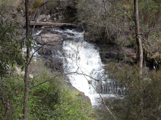
One of the impressive waterfalls on Micalong Creek
We drove our cars the one kilometre to the picnic area we had passed on the way in. This turned out to be Bossawa (Barrois) Camping area and a track could be seen heading through the bush behind the covered picnic area. Claude Bossawa (after whom this site is named) was a member of the Hume and Hovell exploration party in the early 1800's. It has been revealed that his proper surname was Barrois, hence the changing name of this camping area.
We enjoyed the rest of our lunch and I took the opportunity
to walk a small 200 metre section of the track from the campsite that again
crosses the Micalong Creek via a small footbridge before returning to the
cars as everyone headed that way. I was a bit surprised to find everyone
had canned the planned walk to Micalong Swamp with the drivers preferring
to tackle the long drive back to Canberra along the rough Brindabella Road.
It ended up that we spent more time behind the wheel of our cars than walking
the track. However, I was very happy to have done this short walk and gained
some insight prior to next year's attempt to walk the entire Hume And Hovell
Walking Track end to end.