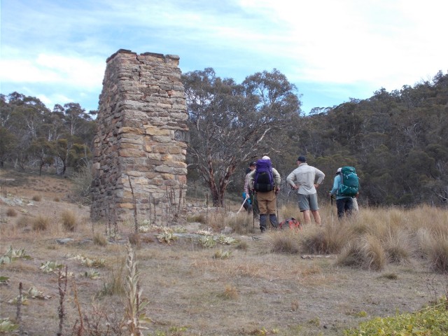
The ruins of Boboyan Homestead
It was a warm sunny late Autumn day with little cloud when we met up with Sean at the designated meeting place in the small park on the south side of the Murrumbidgee River bridge at Tharwa at Midday. The forecast was for cloudy conditions, but the worst we got was some high wispy clouds that hardly blocked out the sun. As expected we packed our warmest gear. Craig was eager to try out his brand new Mont sleeping bag for the first time since buying it almost one year ago, perfect for the estimated overnight temperatures in Namadgi. Of the 16 walkers we were hiking with this weekend there were several familiar faces. Doug, Gerald, Fiona, Michael & Isaac, David and Peter.
We now all drove south along the Naas Road and then the unsealed Boboyan Road for some distance. Our destination was about 11km further along the unsealed road. Our destination, the Old Boboyan Road, not far from the turn-off to Mt Clear Campground where we had commenced the walk to Horse Valley Hut last October. From the car park 800 metres down Old Boboyan Road we would organise a car shuffle, placing most of the cars at our finishing point at Mt Clear parking area.
The ruins of Boboyan Homestead
We arrived at the car park at the start of our walk and waited for Sean and the other drivers to return from organising the car shuffle. We commenced our walk at 1.25pm. We decided to split into two groups, the faster group would head off immediately and head for camp to start collecting firewood and get the fire going. The slower group included those just out to enjoy the countryside, take photographs or just plod along taking in the atmosphere. Naturally Craig and I demanded a place in the slower group. Our destination was the camping area at Westermans Hut, some estimated 14km walk away.
The trail headed westwards through open hilly countryside. It was quite warm in the early afternoon sun and the conversation friendly as we negotiated a small ascent that hardly caused us to raise a sweat. After about 1500 metres we noticed some building remains on a small hillock beside the track. It was mainly a stone fireplace and some scattered metal. This was all that remained of Boboyan Homestead. We stopped to take a closer look at the impressive stone structure before again moving on, our track winding on scenically in front of us keeping a level contour around the low wooded hills.
Heading back to the rucksacks after visiting Lutons Shed
We made our way towards Lutons Shed, dropping our rucksacks at the intersection of Old Boboyan Road and Waterholes Fire Trail, walking the extra kilometre unhindered by a weighty pack. We passed the faster group coming back from their shed visit and it wasn't long before Lutons Shed came into view.
Lutons Shed is an old Crutching shed, some wag suggested it may not be a good idea to enter the shed for fear of being "Crutched". Crutching is the removal of wool and dags from the rear of a sheep to help prevent fly-strike. This large corrugated iron shed is situated within sight of Sentry Box Mountain and has a water tank and a nice camping area on a wooded hill about 50 metres behind it, complete with a stone fireplace. We strode up there to take a look and I took note of the campsite for future reference.
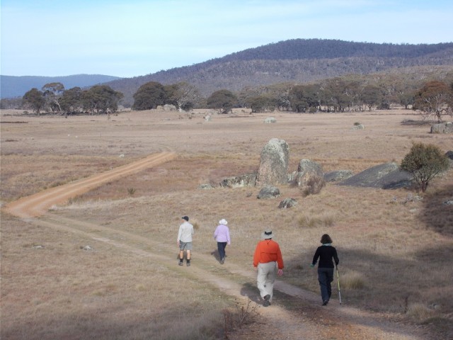
We now returned to our rucksacks and continued our walk along Waterholes Fire Trail as it headed south towards Waterholes Hut. Craig is adamant that 10-12km is his daily limit and now he was feeling the pinch after a long gradual ascent, but he plodded on regardless. I made sure that I didn't get out of his sight by walking faster. At the top of the hill we caught up to Sean who wasn't too far behind Fiona. Sean walked with us for a while and the talk turned to rock music and before we realised, Craig had appeared to get his second wind.
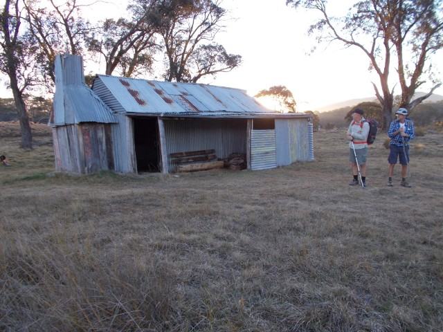
Sean and Craig at Waterholes Hut
We stopped at Waterholes Hut to take photographs and inspect the inside of the hut. Waterholes Hut is located upstream on Grassy Creek, from Westermans hut, almost on the southern ACT border with NSW. Waterhole Hut is on the Namadgi Historic Homestead Triangle, also known as 'The Settlers Trail'. Waterholes hut was built by the then owner, Thomas Oldfield, his son Jack and Henry Tyrie in 1939, to support grazing. Stones were used from the old homestead nearby, for the base to the chimney. the old homestead had been occupied by Thomas Westerman's mother with her second husband, Francis Dwyer. The stock yards nearby, are of note, incorporating large granite boulders. In 2004 and 2005, the hut was fully restored by KHA (Kosciuszko Huts Association) and the caretakers. Waterholes is a simple iron hut with a dirt floor. Sean informed us that this hut has a resident possum known to terrorise hikers.
It was about 3km to Westermans Hut and it was getting late. It looked like we would again be pitching tents in the dark. Only our conversation kept flagging spirits up and then suddenly the sight of tents and a timber hut appeared in the distance. We arrived at Westermans Hut at 5.25pm with the last vestiges of daylight fading before us. Craig and I found a level spot to pitch our tents near some granite boulders about 50 metres from the hut and we were the furthest tents away. Both of us had brought along our Macpac Microlight one person tents for this walk and by the time the tents were up and bedding arranged it was totally dark.
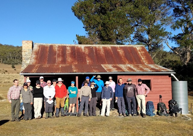
Our entire walking group at Westermans Hut
We carried our cooking gear and food to the hut and set up on the verandah. A tank provided water for cooking and a little further away was a pit toilet. The hut itself had three large rooms, two with fireplaces, but it wasn't too cold to sit on the verandah and prepare dinner at this stage, even though we had to deal with icy fingers. Gloves, beanies, thermal t-shirts and down jackets kept us warm. After dinner we entered the hut to enjoy the warmth of one of the fires. We weren't alone here tonight, there was also a group of Rovers camped outside the hut. We sat around chatting and listening to music on my iPad until 8.45pm when we braved the chill night air to return to our tents and get some sleep.
Already there was a lot of dew on my tent. I scrambled inside and with some difficulty in the confined space managed to remove my boots, stash my food and get into my silk liner and sleeping bag. Almost immediately I fell asleep. It was a very cold night, but I was kept warm with my down sleeping bag and liner. I woke next morning at 7.45am to a totally frozen tent - the fabric was stiff with ice. Sean had organised a morning ramble up nearby Wrights Hill which had the added attraction of a trig on top so I was a definite starter. The only trouble was that Sean wanted a 7.00am start so we could get back an pack up in time to move off at 9. That meant starting without breakfast. I quickly put my down jacket on over my thermal top, put my beanie and gloves on.
I was quite surprised to find that Craig was joining us this morning. After yesterday's exertions I would have thought he'd take the extra time to recover rather than tackle a steep hill. There were six of us doing this morning's walk - Sean, Michael & Isaac, Fiona, Craig and myself. We cut across the fields and stepped over a trail and into the scrub that covered the flanks of Wrights Hill. In some areas the going was rather easy, but mostly it was a difficult scrub bash through thick vegetation as we ascended to the top.
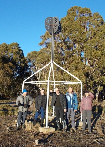
Wrights Hill Trig: L-R - Paul, Isaac, Michael, Craig & Fiona (Photo: S Sunley)
We crossed an old fence line which meant we were now walking in New South Wales. On the summit there was an area of clear grass that was obviously a favoured habitat of rabbits judging by the droppings. Through a gap in the trees we could pick out the trig station, one of those white painted metal contraptions with the vane perched on top that dominate all A.C.T. trigs. There were a few good views to the south east from here too. The obligatory trig photographs were taken and then we returned to camp. The descent a little easier but still a hard slog through the vegetation. We were indeed back by 8.00am.
Once back at our tents Craig and I busied ourselves with breakfast while all the others nearby wasted little time in packing up their tents ready to roll out. Today we would not be walking with Sean or the others. Sean's route was a 10km walk along Burnt Hill Fire Trail to Mt Clear car park. Checking the map, Craig and I had noticed another high country hut that we had never visited and with Sean's permission we were allowed to detour away from the group. The walk was also much shorter at just over 5km, but included a section of Boboyan Road. We had no need to hurry so we allowed our tents to dry in the morning sun before packing up. Sean called everyone up to the hut for a group photograph which one of the Rovers took before they headed off into the hills. Our faster group set off at 8.45am and Sean's group at 9.00 leaving Craig and I totally alone at the hut.
At exactly 10.00am with our tents dry and packed away we put on our rucksacks and headed off towards Brayshaws Hut, ignoring the trail the others had followed. Instead we negotiated the field near where we had pitched our tents and crossed Grassy Creek via a footbridge and followed a well defined foot track that ascended a ridgeline gradually to the north. It was a pleasant trail that made its way through light forest. At one point the trail took a severe left turn at a fenceline and although it looked as if a track continued straight ahead it was obvious the left turn was the way to go, then suddenly the woods cleared to reveal an open field and at one end stood Brayshaws Hut. We had been walking just 40 minutes.
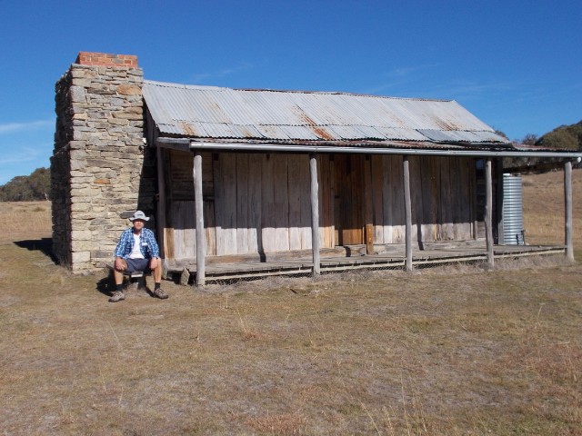
Craig takes a break at Brayshaws Hut
Built in 1903 by Edward Brayshaw for Davey Brayshaw, to support grazing, he lived here until his death in 1931. In the 1960's it was used as shearers quarters. The hut is only about 100 metres away from Boboyan Road and as we stood admiring the hut several cars turned up and parked in the small car park. Several bushwalkers emerged with their packs and wandered over to inspect the hut before heading off on the trail. After 20 minutes we headed for the road and noticed signage that revealed 'The Settlers Track' which is a smaller triangular walk that takes in Waterholes Hut and Westerman's Hut. The trail is only 9km long, a perfect day walk, though utilising many of the trails in the area could easily be extended to become another great multi day hike, like the one we are now finishing.
We followed Boboyan Road northwards, keeping vigilant for traffic which was still quite busy on this dirt road. Many vehicles flew past us spewing up choking clouds of dust. Thankfully we didn't have too far to walk, just over one kilometre before we arrived at the intersection with Old Boboyan Road. This intersection initially caused some confusion as a signpost stated this was the South Road. We followed this road for 800 metres and arrived back at my car at exactly 11.25am. All the other cars had gone. It was obvious that Sean's group had all been here, collected cars and headed home. Sean later informed me their walk was only about 7km and they had arrived back by 11.00am.
Craig and I got in the car and drove home satisfied that
we had found yet another excellent walking trail that has options to expand
the walks into a three or four day hike.