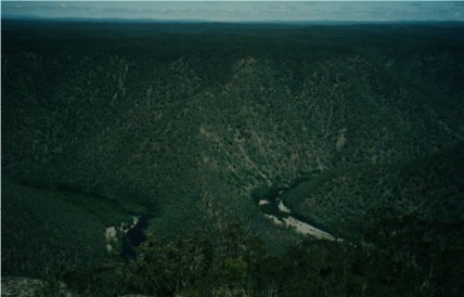
The Great Horseshoe Bend from the top of the Shoalhaven River Gorge
On Wednesday 3rd November I joined Brett & Karen Davis and 9 other Shoalhaven Bushwalkers for a walk I had been wanting to do for many years now. The walk to Wineglass Tor. After torrential rain the day before, Wednesday showed itself with a clear cloudless sky, but there was a stiff chilly most un-spring-like wind in the air. I packed my rucksack accordingly. Brett, Karen and I met the rest of the group at the intersection of the Braidwood and Turpentine Roads at 8.20am. Yes, it was an early start as we had a very long drive to get us to our starting point. Some of the walkers in our group were familiar to me. There was Colin Taylor, who was co-leading this walk with Brett today, Sandra Kelley, Paul Brereton and Chris & Kynie Evison.
We somehow squeezed the 12 of us into two four wheel drives for the long arduous journey along the unsealed Braidwood Road finally taking a right turn onto Tolwong Road not far from Nerriga. Our starting point for the walk was approximately 35km down this rough dirt road which had very little of interest save for the sight of two Wedge Tail Eagles, plenty of burned out bushland from the previous two summers of bushfires and a number of grazing cattle near the major clearings along the road. We passed Quiera Clearing, the site we parked our vehicles last time we attempted this walk and continued driving for quite some time until finally we reached a side track on the left and parked our vehicles. The time was 10.00am.
After signing the compulsory walker's indemnity sheet we followed a faint trail that descended through lightly wooded country, passing another herd of cattle at another clearing. Our boots were soon very muddy from the wet rain-soaked soil, but once we hit the scrub proper this was not a problem. Finally, after a gradual descent we reached Tim's Gully, crossed the creek and stopped for morning tea.
Continuing on we were immediately faced with an ascent to the top of the ridge known as Wineglass Spur. The ascent was short, but very steep but we managed to reach the top without having to stop to catch our breaths, though I was regretting the morning tea cigarette I had just smoked. On top, the going was much easier as we headed through the forest in a south-westerly direction. There was no defined trail, we just kept to the top of the ridge and followed this for about 45 minutes. The bushfires through this area had made our walking quite easy, normally this walk would have been a horrific scrub bash that could have taken hours. Today we were walking in open forest with the sight of regenerating trees all around us. We kept our eyes on the tree tops for signs of Koalas, as they can be found in numbers in this area of Morton National Park. However, we saw none, except for the tell tale scratches they make whilst climbing the tree trunks - these were pointed out to us by Colin. A small ascent further on brought us to the edge of the Shoalhaven River Gorge and despite the strong windy conditions we marvelled at the great views before us. Way below us was the Great Horseshoe Bend. To the far south on the horizon we could pick out Currockbilly Mountain and Mount Budawang. Below us the ground sloped it's way to the river at the bottom of the gorge. You could see it was possible to scramble all the way down, but this was not on our itinerary today (thank goodness).
The Great Horseshoe Bend from the top of the Shoalhaven River Gorge
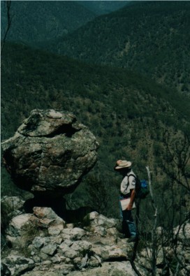
We followed the cliff tops south for a short distance, stopping at Touga Trig for the obligatory Trig Station photograph (and another Trig claimed) and shortly afterwards reached the famous Wineglass Tor. The Tor is a rock formation on the edge of the cliff, shaped like a wineglass. It really isn't that large, about the size of a phone booth, maybe just a little bit bigger, but it is surrounded by Xanthorrea plants (better known as 'Black Boys') and with the gorge below, it makes quite a photogenic moment (or is that a 'Kodak Moment!') Behind the Tor was a view of the Shoalhaven River far below. Further south, out of sight, was Little Horseshoe Bend. It was decided to work our way around to get some views of this feature of the Shoalhaven River. We had to head inland though as the cliff was now bisected by a number of gullies. The route to Specimen Hill, where we hoped to get some views of the bend was undulating and took a fair amount of time to reach. Alas, once at the top of Specimen Hill our views of the Little Horseshoe Bend were obscured by trees, though we could pick out parts of the river.
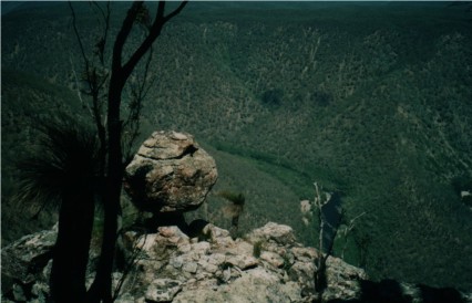
Two shots of the Wineglass Tor - below, Colin Taylor takes a closer look
We now headed back to find a suitable spot for lunch. Instead of backtracking to Wineglass Tor we followed another ridge which descended to a feeder creek to Tim's Gully. This route caused some consternation among our co-leaders as there were several feeder gullies coming off this ridge and they needed all their navigation skills to select the proper descent (I wished I'd brought along my GPS - it could have saved more time). Along the way we disturbed a White Throated Nightjar that was sitting on the ground, a very rare species in this area and the only Nightjar that can be found in these ranges. The bird flew away revealing a recently laid egg on the bare ground. The amazing thing was that there was no distinct nest. The bird had laid the egg on the bare ground. We reached the feeder creek, noticeably with running water after the recent rain and stopped for lunch. Colin had brought along a book which had quite some information of the history of this area and spent most of the lunch break quoting interesting snippets of information from this book. From my lunch spot, away from the others (due to my smoking habit) I had a good view of the junction of these two small creeks, one which tumbled down from a nearby ridge in spectacular steps in the rock. In not so drought ravaged times as ours I gathered this feeder creek would look quite spectacular.
With lunch over we followed the creek eastwards for about one kilometre until it met up with Tim's Gully, then followed this creek northwards for some distance. We constantly found ourselves crossing the creek many times and soon found evidence of the old gold mining areas along this gully, eroded banks, rock walls, open holes in the ground and the occasional rusted piece of metal. The water in the creek was crystal clear. I'd never seen so many stinging nettles since I'd left England 35 years ago. Only one snake was seen during the day and it was along this section. A brief glimpse of a Red Belly Black snake as it slithered across the bank into the scrub.
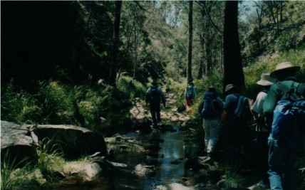
Shoalhaven Bushwalkers negotiating a route along Tim's Gully
As we neared Peach Tree Canal, we crossed the creek via a large fallen tree log and found ourselves in a major gold mining area. There were large holes everywhere. Colin went searching for the remains of the famous bakers oven, which he eventually found while the rest of us explored the Peach Tree Canal. The canal was dug by the gold miners in a bid to alter the course of Tim's Gully Creek and, draining the water from one major bend, hopefully reveal some riches. In later years, one of the miners had planted a Peach tree in the now waterless canal and this we now searched for, locating only a burnt stump which revealed the tree had become a victim of the last bushfire.
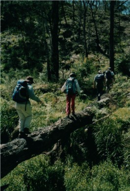
Shoalhaven Bushwalkers crossing Tim's Gully to Peach
Tree Canal via a fallen tree trunk
We now followed the creek for some distance cutting the
hairpin bends in the creek which meant regular ascents and descents up
and down the small ridges, until we reached the spot where we had morning
tea, then it was the long gradual ascent to the vehicles, arriving at the
cars at 4.00pm before taking the long drive home.