
Squizz, Julie & Paul at Cooma Cottage near Yass - The official commencement point for the Hume & Hovell
Part 1: Cooma Cottage to James Fitzpatrick Trackhead
Seven years ago in 2011, I started to take renewed interest in attempting the walk, especially after spending time with the Shoalhaven Bushwalkers at their annual Laurel Hill week near Tumbarumba where sections of the nearby Hume and Hovell Walking Track were walked by the club as easy day bushwalks. I started to plan the walk and commenced purchasing topographic maps that contained sections of the track, planning each individual day and campsites. I still had no interest from anyone else wanting to walk 440km over 25 days and considered doing the walk solo, utilising food drops left in the bush near the track. Several others have successfully completed this track this way and it helped inspire me to finally commit to taking part. I decided that April 2018 would be a great time to put this on. My 60th birthday would be celebrated that month and I decided it would be a great excuse to celebrate this milestone by taking part in something memorable to remember it by rather than the obligatory birthday party. However, during the past 12 months several bushwalking friends started to show interest in the project, with Ian ' Squizz' Taylor (once a fellow employee and now regular hiking companion) and former Shoalhaven Bushwalker Julie Davison (now living in Queensland) keen to join me for the entire walk.
Others soon put their hands up. Fellow Canberra Bushwalkers Sean and Julie Sunley showed interest in joining the walk for the seven day section between Tumut and Tumbarumba while Jacqui Rosier and Gerald Dodgson were keen to walk from Wee Jasper to Tumut. Our final companion was Shoalhaven Bushwalker Jennifer Himmelreich who was keen to walk the last stage from Tumbarumba to Albury. To allow walking friends to come in and leave at certain sections of the track it was decided to put on two rest days, splitting up the track into three sections. Those days would be near Tumut and Tumbarumba. My hiking friend Craig Rayner then stepped in offering to provide transport of the food drops for the three of us walking the entire track at both planned rest days, saving us the chore of placing and retrieving the food before, during and after the walk. This also worked out very well for Julie as time restraints travelling from Queensland on the weekend prior to the commencement of the walk would have made it almost impossible to organise her food drops and place them in the planned locations in the bush.
We were lucky enough to organise accommodation for before, during and after the walk and with the help of friends, organise transport to the start and from the finish. Others would utilise car shuffles where they start and finish their walking sections while some were able to organise a lift with Craig when he drops off our food. The final objective for me was to upgrade some of my equipment to suit this long walk and go on an exercise and diet regime that saw me reduce my overall weight by almost 25kg. I purchased a PLB (Personal Locator Beacon), a new GPS handheld receiver and a rucksack big enough to carry all my gear and food for the trip. The rucksack, a Macpac Cascade proved to be a stressful addition where I had big issues with adjusting the rucksack's harness system. On several walks over the previous 12 months I had nothing but trouble getting this correct, to the point where I seriously considered changing to one of my older rucksacks. Even a visit to my local Macpac store could not gain assistance. In the end, after many trials and adjustments I got the pack to the best possible fit I could manage. However, as a precaution I chose to leave one of my older rucksacks with Craig for the first food drop just in case I have further problems. The Mont Flyte pack is 10 litres capacity smaller than the Macpac, but it has an easier harness system to adjust.
Squizz, Julie & Paul at Cooma Cottage near Yass - The official commencement point for the Hume & Hovell
A couple of days before the commencement of the walk we dropped our food packages at Craig's place and then set about packing. My first attempt found a fully loaded rucksack that weighed in at 22.7kg, which included my daily water requirement of 3 litres, almost the same amount of weight I had lost over the previous year or so. This forced a rethink about some of the gear I had chosen and I made the hard decision to remove some equipment and clothing for lighter alternatives and cut back on some of my trail snacks, asking myself the question "Will I really need this on the walk?". In all I managed to cut down 2kg and was quite satisfied with that and I was happy in knowing that the rucksack will get lighter each day from the start of the walk and each of the two subsequent food drops as food and other items are used up.
On Monday 16th April 2018 my house mate Glen drove Julie and I to Yass where we were booked into the Hamilton Hume Motel at midday and waited for Squizz to arrive. He duly showed up at 2.15pm with his son Lee who was acting as Ian's taxi driver before driving the car home to Canberra. Glen also drove myself and Julie to the entrance of Cooma Cottage on the northern side of Yass. Our plan was to walk back to the motel from here, approximately a 6km walk along the Yass Valley Way. We strolled down the driveway to the cottage which was closed. It is only open Fridays through to Sundays, but this is where the official Hume and Hovell Walking Track commences. Lee took a series of group shots of the three of us standing in front of the cottage complex. This is where Hamilton Hume spent the last years of his life.
Under a large tree is a signpost and a series of information boards about the track and the history of the 1824-25 exploration and the sign tells us we have 440km to travel to the Hovell Tree on the banks of the Murray River in Albury. Once all photographs at this spot had been taken we walked back up to the road where we said our goodbyes to Lee before heading along the roadside back towards Yass.
It was cool and overcast as we made our way along the roadside. Apart from wearing our raincoats, we had a variety of small carriers such as bum bags to carry water. We certainly avoided putting on the heavy rucksacks for this section and we were thankful for the jackets as the chilly wind picked up. There were no official tracks as such, we just walked along the grass verge or the road's shoulder until we reached town. The rural sights weren't bad but the noise of the traffic took away some of the enjoyment as did the high amount of roadside rubbish. We were happy to be walking away from major roads for quite some time as of tomorrow.
It wasn't long before we found ourselves walking through the main street of Yass. All the walking so far has been easy with hardly anything in the way of ascents except for a short uphill section negotiating the bridge over the Yass River. We took the opportunity to check out somewhere for dinner tonight and chose one of the town's pubs which advertised low priced Monday Steak Night. During the last 500 metre section of footpath Julie started to have problems with hot spots on her feet and stated she would be strapping them when she got back to her room. The entire walk back took exactly one hour.
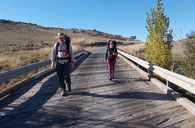
Squizz and Julie crossing one of the rustic road bridges on Black Range Road
Once in my room I got on my mobile phone and made a courtesy call to Burrinjuck Waters Holiday Park to confirm our campsite bookings for Wednesday night and the subsequent boat trip across Lake Burrinjuck the next morning. The entire package costs just $40.00 each. Our booking was confirmed and we were informed that we needed to arrive no later than 5.00pm before the park office closes.
Day 2 and my 60th birthday. It's 7.00am as we gathered in the courtyard of the Hamilton Hume Motel, our heavy rucksacks already on and raring to go. It is a chilly morning, but the sky is clear. It was going to be a warm day. We immediately set off, walking along the Yass Valley Way through the town's southern outskirts, dodging traffic as they drove past. Yet again there was very little in the form of footpaths but we did see a HHWT sign. After 45 minutes and approximately 5kms we arrived at Black Range Road turn-off and turned left, ignoring the opportunity for extra breakfast at McDonalds at the Yass Service Centre just 200 metres further on.
The walking became a lot quieter with less traffic, but we could hear the rumble of trucks making their way along the nearby motorway, but they got fainter and fainter the further we walked. We had a few cars go past from time to time which we deduced belonged to the landowners of this region. There was some nice rural scenery from the roadside that included nearby hills and the rising sun soon warmed us up. The hard bitumen soon gave way to gravel as we crossed Bowning Creek bridge. The terrain was hilly but never steep. My rucksack was still causing problems and many stops were spent attempting to adjust the harness system to a point where it became almost comfortable, I still had to keep making adjustments as I walked, it was most frustrating. If this cannot be resolved by the time we arrive in Tumut for our first food drop Iíll be swapping it for the Mont pack I left with Craig.
We took regular stops around each hour either to take a drink, eat a snack or just catch our breaths after an uphill section. The road again became bitumen for a short distance before we hit unsealed gravel again. Our calculations revealed that today's walk would be in the vicinity of 26km, a fair distance with a fully loaded rucksack each, but this would help get us road fit for the walk ahead. On the downside, we would end up with foot problems that would dog us for the next few weeks.
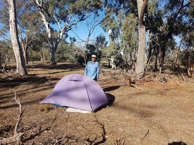
60th Birthday Boy at Captain Campsite - Photo: J Davison
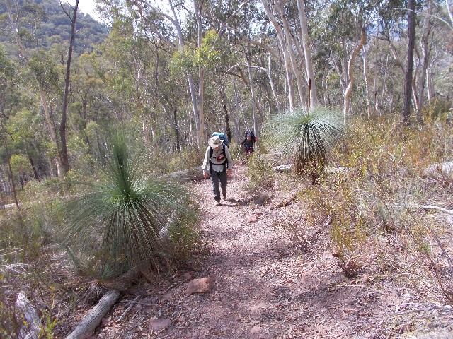
There were several wildlife sightings such as rabbits that would run out onto the road in front of us, a Shingleback lizard crossing the gravel or Eastern Rosellas that flew over the road to alight on the roadside fence. A Kookaburra could be heard laughing in the distance and at the spot we enjoyed a brief lunch we got the reward of watching a distant Wedge Tailed Eagle soaring on the thermal draughts above us. Farm animals we witnessed ranged from cattle, sheep, alpacas, geese, horses and during the next 24 days we would see llamas, camels and ducks. We would awake each morning to the screeching sounds of Sulphur Crested Cockatoos while Yellow Tailed Black Cockatoos were a daily sighting, especially during mid mornings. Other birdlife included Gang Gang Cockatoos, White Bellied Sea Eagles, Lyrebirds and a wide range of scrub birds such as Wrens, Finches and Honeyeaters. Marsupials abounded. Eastern Grey Kangaroos, Rock Wallabies, Emus, Wombats and the Australian mountain horse, the wild Brumby. The occasional trout made its presence known in some waterways. We saw a range of different spiders, plenty of ants, but not one single snake.
After a gradual ascent that went on for some distance we arrived at a spot we designated as suitable for lunch, even though it was only 11.45am. It was great to get the heavy packs off and enjoy some fluids and a snack. We guestimated (from Ian's ëFitbití) that we had already travelled 19km so far, we were doing excellent time (though we later discovered that Ian's settings were a little out). We checked our GPS and maps to discover we were possibly only 5.4km from Captain Campsite.
When we continued, the road descended gradually for some distance before ascending again and we were soon feeling fatigued. Some of us had issues with hot spots on our feet, but still not bad enough to create blisters yet. I later discovered that the narrow last on my leather Scarpa boots were jamming my toes together with the result being that I lost three toenails immediately after the walk finished with two others remaining black for many weeks. Now each step became laboured as we shuffled along the hard gravel road with heavy rucksacks on our backs, thankful for the invention of trekking poles. My waist was sore from the tightness of my rucksack harness belt, but I had to have it tight or the rucksack slips below my waist.
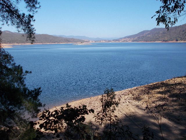
Lake Burrinjuck as seen from the Hume & Hovell Track not far from Burrinjuck Waters Holiday Park
We started to wonder about our distance calculations as the road continued on and on. Half expecting to see the campsite over the next small hill or around the next bend. We had somehow missed the Crown Reserve Rest Site earlier which we planned to use as a distance guide. Julie started to drop back a little as her feet became very sore. Another worry was our dwindling water supply. In the early afternoon heat we had used up most of our drinking water (I had less than 100ml in my hydration bag when we reached camp, the others had even less)
Finally, at 1.45pm we arrived at a stile just off the left side of the road and we crossed over onto Captain Campsite. We had walked 24.5km today, according to my iPhone's GPS calculation. The site has a toilet, water tank, covered picnic table, fireplace and a rubbish bin. The campsite is named after the lead bullock from the Hume and Hovell expedition. There is also a logbook in which Squizz eventually made an entry (Ian became our trip's logbook writer) The first thing we did was remove our rucksacks and hot sweaty boots before replenishing our water supplies from the tank and organised either Hydralyte drinks, tea or coffee, or all the above. It didn't take long for our sweat soaked shirts to dry in the afternoon heat and we soon selected our tent sites.
The main problem was locating a spot that wasn't directly situated below dead timber. There were plenty of trees here that provided lovely shade from the afternoon heat, but pitching a tent under eucalypts can often be dangerous due to falling branches. We took several trial sites before choosing our spots and I quickly put up my Macpac Microlight. Like many of the campsites along the HHWT, this ground was rock hard and several tent pegs got bent, luckily they are easily fixed.
The campsite's location allowed our smart phones to get a decent phone signal and I spent the next hour taking texts and voicemails from friends and family wanting to wish me a happy 60th birthday. Julie took a birthday photograph of me standing next to my tent. We returned to the shelter to get ready for dinner but with the sun not due to set until 5.30pm we had plenty of time, so we ended up playing one of Ian's dice games called "5's and 1's" before we cooked dinner. Ian had been busy writing in the logbook and had composed the following poem which I thought was quite good -
Paul, Squizz and Jules went by
We're sitting here we wonder why
We're going down to Albury
We're going to see the Hovell Tree
This is but day one
Of 3 week's joy and fun
We sit and think the 3 of us
We should have caught a Greyhound bus
It soon got dark and chilly, Julie retired to her tent at 6.30pm while Squizz and I chatted by the campfire until we retired to our respective tents 30 minutes later. The bleating of the sheep in the next paddock kept me up for a short while but I got a great night's sleep and certainly wasn't cold in my sleeping bag. Sometime during the night I was awoken by some serious grunting and growling near my tent. I had obviously pitched too close to some animal's lair and was blocking its pathway. I was again awoken next morning by noisy Kookaburras and screeching Sulphur Crested Cockatoos and eventually got out of my tent at 7.05am to greet another glorious cloudless blue sky, although once again a little chilly for day 3.
Everyone else was already up and I joined them for breakfast at the shelter before returning to the tent to pack up. I discovered the burrow on the other side of a tree just 20 feet from my tent and deduced it was a disgruntled wombat I had heard growling last night. There was very little condensation on my tent and that was under the floor. It didn't take long to dry. We were packed and ready to go at 8.45am. We estimate a 22km walk today with our destination being the Burrinjuck Waters Holiday Park. We climb back over the stile and turn left, following Black Range Road for two kilometres until we reached the bitumen at the intersection of Woolgarlo Road. We turn right, greeted by the incessant bleating of nearby flocks of sheep.
Ready to board the boat at Burrinjuck Waters Holiday Park for the ride to Cathedral Rock
The walking was easy and the chill air kept us cool as we walked the 1.7km to Burrinjuck Road which was marked by a HHWT post which we took the opportunity to have photographs taken with. We turned left and followed this bitumen road for 5km. After a 20 minute break at 9.50am we passed by a line of dead foxes, hung up on the farmer's fence, along with a large feral pig. A sign stated these animals were shot after moving down from the Burrinjuck State Park.
At 10.50am we turned off the main road, leaving the bitumen behind at a left fork where a signpost states the gravel road leads to Riverview. Julie's map states we have just passed the 40km mark of the walk, just 400 more to go. This road ascends gradually to pass through a gate and over a cattle grid at the top and we find a large fallen tree log to sit on for an 11am morning tea break. My rucksack appears to be sitting better today, though still far from perfect. I'll take it like this though, a lot better than on a couple of previous walks where the weight was a lot less. Squizz is wondering where the "Riverview" is. He's expecting to see views of blue water from up here, but all we have is masses of trees in the way. 'Riverview' is the name of a property nearby.
After a 20 minute break we continued on as the trail entered pleasant forest, descending gradually by several sheep farms and stopped for lunch at 12.15pm on a large log lying next to the Link Trail intersection before continuing 30 minutes later. As the trail descended Squizz noticed a cutting which we considered may have been constructed for the railway that serviced the construction of Burrinjuck Dam before WWI. We were still expecting views of the lake, but we still had a fair way to go. Eventually, at 1.25pm the first blue water views of Lake Burrinjuck came into view, but still blocked by many trees.
Soon after we turned off onto a foot track, the first for this walk and it felt great after more than 45km of bitumen and gravel roads. The track descended through the forest for a short distance before crossing a small creek. On the other side the track suddenly ascends to follow a contour high up above the creek. The track is very narrow and next to a steep drop, so we tread very carefully. The creek becomes an inlet to the lake and is presently very dry.
The track continues, lower in the forest and just above the mudflats of the Lake. We did get some great views of Lake Burrinjuck along here and a few photo opportunities were taken up. The water level is extremely low, revealing kilometres of bare mud flats which take away from the beauty of the lake but we can see out to Cave Island where the Goodradigbee and Murrumbidgeee Rivers once met prior to the dam being built. Lake Burrinjuck is claimed to hold more than three times the volume of Sydney Harbour when at full capacity.
We followed the lakeside track as it now took the long detour around the dry inlet of Carrolls Creek. This section provided great walking but was frustrating for Squizz who took the first opportunity to cross the dry mud flats to the track coming back on the other side. I was determined to follow the track to the letter for its entirety and continued with Julie in tow and even she got exasperated as the track continued on and on until at last we crossed a dry spot where casuarinas (Sheoaks) grew along the creek. We followed the track on the other side and soon caught up to Squizz who had been patiently waiting for about 15 minutes.

View of our track heading towards Wee Jasper with the Brindabella Ranges in the distance
The track continued along the lakeside until finally, at 2.50pm, we stepped out onto Burrinjuck Waters Holiday Park. We dropped packs in the campers kitchen and looked around. All of the camping areas looked bare and grassless, not very inviting at all and thoughts of sleeping in the campers kitchen tonight were considered, even though there were signs prohibiting this. Squizz and I decided to head for the park office to pay our camping and boat trip fees while Julie looked after the rucksacks. Maybe we could find better grass covered campsites further on. It was a fair walk to the park office, located at the other end of the park and in the end we decided to hire a cabin for the night. For the three of us it worked out very cheap and also reduced the cost of the boat tomorrow by $10.00. Squizz and I grabbed some refreshments from the general store and returned to grab our rucksacks and give Julie the good news. We spent the rest of the afternoon having showers, washing clothes and sorting gear, then making our dinners. By 9.00pm we were all snug in our sleeping bags on comfortable camp bunk beds.
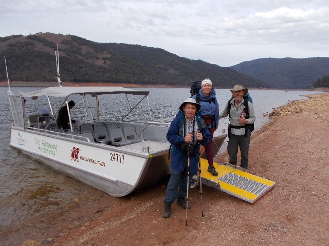
It was a good night's sleep, but we needed it. We were all up at 6.30am on day 4, despite setting our alarms for 7. We busied ourselves with breakfast and packed our rucksacks. Outside it was overcast and a chilly 11 degrees. Rain was forecast sometime today. At 8.10am we left the cabin and walked down to the boat launching area, a small beach to the west of the park, to catch the 8.30 ride to Cathedral Rock. Dean, the boat's operator showed up at 8.20 with the boat in tow and we took the opportunity for a group photograph in front of the vessel. An elderly couple also came down to watch us leave.
The boat left at 8.40 for the 10 minute ride across the lake. The water was relatively still, so the ride was quite enjoyable for the 6.5km journey. Arriving at Cathedral Rock we stepped off the boat onto the mud flats and farewelled Dean, who pointed us towards the track and we set off, crossing the grassy embankment and locating the dirt road not far from where it passed the location for the Annual Dragon Dreaming Festival. We are now walking through sheep grazing country and there are plenty of them. Many running away as we approached them. The country soon changes to limestone and there are many outcrops by the road, but it is below where there are labyrinths of underground caves. We took a quick break at 9.50am by a limestone outcrop and by now the clouds were clearing. We were soon walking again under a clear blue sky. To the south we had wonderful scenic views of the surrounding mountains and hills, many of them forming the Brindabella Ranges that form all the way to near Canberra.
We passed by the "Duck & Fishes" B&B then passed the side road to Careys Cave. We crossed the first of many livestock grids we would come across today and more stiles. When the road became bitumen we followed it to the village of Wee Jasper and stopped for a lunch break at Careys Reserve where we tended to Julie's sore feet which are not getting any better. We also made further adjustments to my rucksack which seems to have made a difference.
Squizz and Julie climbing the ridge behind Wee Jasper Village
35 minutes later we headed into Wee Jasper and quickly passed through. Just outside of town we were greeted with the sign to the local tip. Here you can follow the track the back way to James Fitzpatrick Camping Area which is 7.5km long or, follow the bitumen road for 3.7km to the same destination. As it was only 12.20pm and we had had enough of bitumen and gravel roads for the majority of the trip so far we agreed to take the longer more interesting track.
We left the road and walked past the tip then followed a faint but well signposted track through the bush and alongside a fenceline. After crossing a stile we started ascending a very steep hill. The track was now very well defined and made its way past grass trees and scribble gums and we took breath catching stops where required. Another 20 minute stop was enjoyed at 1.00pm when we came to a large fallen tree trunk. The track continued uphill and then levelled out for a short distance before reaching a dirt fire trail.
We turned left and followed this uphill where it gave us views back to Lake Burrinjuck through the trees. Just as the trail started descending a HHWT signpost forced us into a right turn onto a forested foot track that descended steeply through the trees. It was a long descent through some wonderfully scenic brittle gum forest, their trunks almost pale white resembling Ghost Gums, made for a couple of great photographs. The track descended down to a grassy field. The section we have just walked was one of the most enjoyably scenic sections so far on the entire walk.
We started to follow the track back towards James Fitzpatrick Camping Area. I had done a walk through here several years ago, but got confused when a HHWT signpost appeared to be heading uphill towards Mount Wee Jasper, our destination tomorrow. I knew I had to ignore that track and we continued to a dry creek where we caught sight of a car following the Wee Jasper to Tumut Road, I knew we were in the right area but nothing looked familiar. Confusion reigned, even a check of my GPS revealed we were well off track and we realised that the gpx file of the walk was created by someone who had taken the bitumen road option from the tip instead of the one we had taken. We crossed the creek and checked out old roads that seemed to take us away from where we should have been heading. Arguments caused tempers to flare up temporarily for the first time on the walk and the only way to sort the problem out was to return to the last known signpost and follow that.
100 metres later we came to a junction that revealed the real track to Mount Wee Jasper, in an almost identical section to the one we had come to previously. I was just glad we hadn't spent too much time looking for the track. I was reprimanded by my companions for my carelessness and told to just follow the signposts from now on. Chided, I fell silent as we followed the trail through some pleasant limestone cave country for 1.3km to arrive at James Fitzpatrick Trackhead and camping area at 3.30pm. We were suitably exhausted after a detour that took us up to the top of a steep hill and down the other side, but it had been well worth the effort.
James Fitzpatrick Camping Area is named after one of the convicts who accompanied Hume and Hovell on their expedition. There are six campsites named after the expeditions convicts and this is the first of them. The campsite features a covered kitchen complete with electric barbecues and even power points to charge our iPhones, iPads and watches. The toilet block features hot and cold running water and a couple of shower sheds which we utilised. The camping area was empty so we had the kitchen area to ourselves. The water taps around the camping area have warnings against drinking, but there is a safe bubbler next to a hot water laundry tub. The bubbler pumped out hot water and the laundry tap cold water when I attempted to top up my hydration bag and camp water bladder - obviously the pipes have got crossed. There is also an honesty box to pay camping fees. $12.00 per adult per night, and although rangers do turn up from time to time to collect fees, I filled out my form and added the money to it and placed it in the box. We took turns in using the shower sheds and noticed during the afternoon that non campers (possibly from the caravan park or other camping areas nearby) showed up to use the facilities.
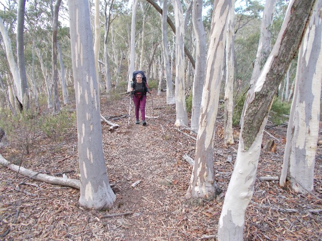
Julie follows the track through a forest of Brittle Gums during the descent to James Fitzpatrick Trackhead
At exactly 4.00pm we were joined by Gerald Dodgson and Jacqui Rosier, two Canberra Bushwalker friends of mine who are joining us for the 4 day section section from here to Tumut. After introductions were made we pitched our tents on the hard ground. Again the pegs were hard to drive in but I managed with the help of a small rock. After dinner Julie again retired to her tent at 6pm while the rest of us remained at the covered kitchen kitchen, dealing with the flying insects attracted by the solar lighting of the shelter.
I taped up my toes and feet again prior to retiring, discovering and accidentally breaking a small blister on one of my toes. This means that all three of us have succumbed to blisters on our feet this walk so far. Little did I realise that our blisters would get a lot worse. Being the last person up, I retired to my tent at 7.30pm. Once again I slept well and was up next morning at 6.15am and I exited the Microlight to greet a clear sky and chilly conditions. I wondered what happened to the rain that was forecast yesterday.