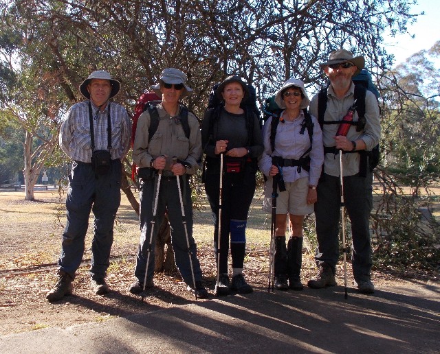
Group photograph prior to leaving James Fitzpatrick Trackhead. L-R Paul, Gerald, Julie, Jaqui and Squizz
Part 2: James Fitzpatrick Trackhead to Tumut
We retraced our footsteps from yesterday past the limestone outcrops for 1.3km then turned left at a stile and crossed the fence. We followed a track through a field and followed a fenceline to another stile and set off on a track through the bush that ascended at first via a number of benched zig-zags. The track soon descended gradually to a bend with views over the Wee Jasper State Forest and all you could see from here was pine trees. We then started to ascend steeply up a forestry road which quickly became a track and we continued to ascend, often having to negotiate trees that had fallen over the track. There were heaps of them and it was obvious that there had not been any track maintenance here for some time. Either that or a severe storm had hit the area just recently. We continued to ascend, crossing a couple of foot bridges over dry creeks before I called for a morning tea break at 10.15am.
Group photograph prior to leaving James Fitzpatrick Trackhead. L-R Paul, Gerald, Julie, Jaqui and Squizz
By now I noticed my left heel had started to rub so the stop was useful in treating the problem by taping the spot with Micropore tape which seemed to help. I led the way the entire day but everyone kept in a group and no stragglers or anyone heading off way in front. The ascent seemed to go on and on without an end to the climbing. We crossed a couple of bridges where a running creek cascaded down an incline. The narrow track here was difficult due to the overgrowing blackberry vines. The one thing I did notice was that I was not suffering cramp problems like the last time I walked this section a few years ago.
The blackberry bushes were really thick in places and grabbed at our packs and clothing, but much of the forest made for pleasant walking, especially on the flatter sections. At 11.50am we came out onto a forestry road where pine harvesting had been recently completed. The hills were bare save for the dome of Wee Jasper's summit which appeared before us. The harvested pines had revealed mountain views back towards the town of Wee Jasper that were once blocked by huge pine trees.
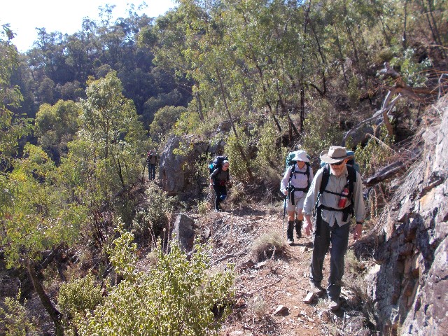
Part of the track that ascends to the summit of Mount Wee Jasper
We turned onto another forest road signposted with one of the HHWT signs and another revealed where to leave the road and follow the track up to the summit, again a steep climb through the forest. I arrived at the summit clearing at 12.25pm and waited to greet everyone as they arrived. We had done so well on a day where the temperatures were expected to get quite high for this late in the Autumn. My shirt was drenched in sweat from the exertions and a signpost informed us we had walked 7.8km this morning and had only 4.3km further to walk to camp. The summit stands at 1121 metres above sea level.
I felt we had earned a decent rest break and called for a one hour lunch and a chance to take photographs and then take in a few south-east views that weren't blocked by tall vegetation. Group photographs were organised next to the trig. There was also another logbook, the second for the walk so far and Squizz got creative yet again with another poem
We finally made it up here
And I would have to say
That climbing Mt Wee Jasper
Is one way to spend the day
This statement is ambiguous
It is neither good or bad
The view from here is gladdening
But my legs are feeling sad
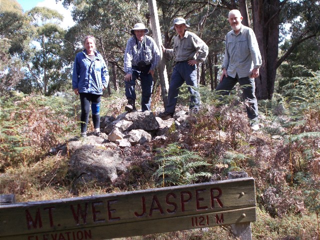
Standing on the summit of Mt Wee Jasper: L-R Julie, Paul, Gerald & Squizz - Photo J Rosier
I took a short stroll to where I could get some views through gaps in the trees. I'm not sure what mountains I was looking at but they did form part of the Brindabellas. The descent through the forest on the other side of the summit was longer than I remembered and it required finding our way around one of the biggest fallen trees I had ever seen. 25 minutes later we were back on the forestry road and making our way through a bare landscape of harvested pines for a couple of kilometres. Although not very nice to look at, it did provide some views of the countryside and a great group shot of us was taken by Julie.
A HHWT signpost showed us where to leave the main road and after negotiating a pile of dumped pine tree left-overs, follow a fenceline to meet a track that took us through some nice forest full of kangaroos and down to Pheasants Creek which we followed on a track that was overgrown with blackberry. Pheasants Creek is named after Hume and Hovell saw a lyrebird in this area which they thought was a pheasant. We crossed the creek on a small footbridge and followed another track for about 300 metres to Log Bridge Campsite, arriving at 3.00pm. The campsite has a pit toilet, covered shelter with table, uncovered picnic tables and two open fireplaces. The site has two main camping areas on two levels that is bordered by a fast flowing creek.

Getting a rare view of the Brindabellas after pine forest harvesting - Photo: J Davison
We quickly set up our tents and gathered water from the creek which in places looked cloudy, but was drinkable. When unpacking I discovered I was missing one of my Leki trekking poles during the afternoon's walk and was surprised no one behind me had seen it on the track. It was stashed on the side of my rucksack, but obviously had been reefed out by a low branch or blackberry vine. I wasn't very happy as these poles were quite expensive and having two meant I could utilise a washing line to dry my clothes after having them washed. There were only two places I thought I could have lost the pole, during the walk alongside Pheasants Creek where the blackberry grew quite thick, or at the start of the track where we had to negotiate the dumped pine branches. However. looking at the photograph Julie had taken of us from the back just after coming off Mt Wee Jasper showed the pole wasn't on my pack then. Squizz suggested after the walk that he would ride his motorbike through here and see if he could find the pole as he was considering taking a look around anyway.
My rucksack problem seems to have been averted for now as I have had no issues with it since before Wee Jasper village. It was almost comfortable on my back the entire day. I did my washing even knowing the clothes wouldn't dry overnight and hung them on bushes. I checked my feet and realised that the tapes I had put on my heels had been pushed off by my boots while walking. What was revealed was broken blisters on both heels of my feet. All I could do was put padding on them and tape them again. Today's exertions in the heat had also caused me to get chafing on my legs and the only way to treat it was to put the pure alcohol of the Aqium gel on the sores. It stung like hell and hurt, but it worked. I had no further chafing problems for the entire walk so long as I kept the area clean. I organised my dinner and sat by the campfire with Gerald, Squizz, Julie and Jacqui before we all retired to our tents by 6.45pm. We had another big 20km day tomorrow.
I was awake at 5.00am and exited the tent one hour later after another great night's sleep. Day 5 was going to be an early start as we had some difficult terrain to negotiate as well as just over 20km in distance. It was another fine sunny day and another chilly morning. The temperatures weren't going to get so high today. Of course my washed clothing was still damp so I packed them in a plastic bag and strapped them inside the webbing on my rucksack.
We left camp at 7.45am. The chafing on my legs had calmed but my heels were sore from the broken blisters. Again I taped them up and hopefully my boots wouldn't push them off again. We crossed the creek and ascended the ridge via a recently well maintained track, which we found was the case for most of today (apart from the foot bridges) and soon came out onto a forest road which featured pine forest on the right side and native vegetation on the left. We followed this for a short distance then turned left onto a wide track for a while. All the signage was excellent and easy to see. I had been concerned with today's walk as it was in an area that has been deemed difficult to navigate - we had no issues at all. Eventually we followed a foot track that started to descend a narrow track to cross Miller Creek. Yellow tailed black cockatoos were in abundance here and we were to see and hear them and their distinctive call whenever we walked through sections of forest.
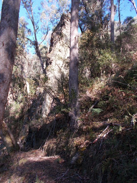
Pompey Pillar
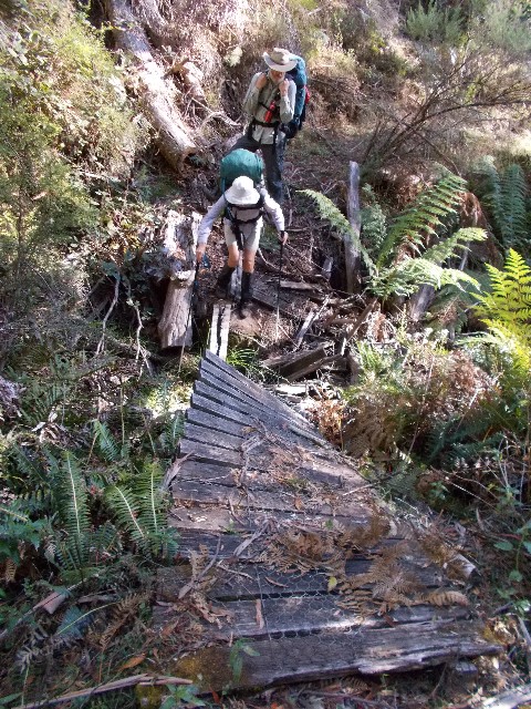
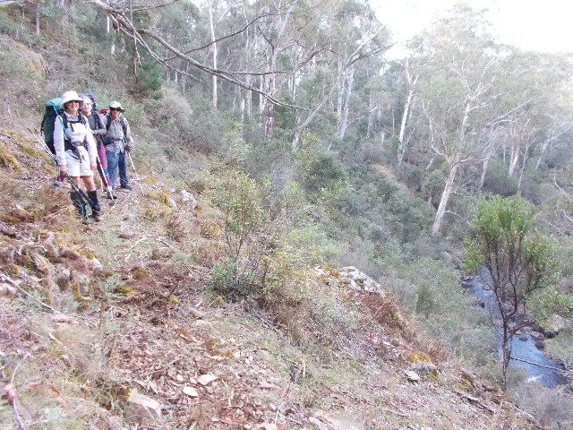
We crossed a damaged footbridge over Millers Creek (the planks askew at a strange angle) and found ourselves on a narrow benched track high above Millers Creek Gorge. We were careful here as one careless footstep could send you plummeting down the slope. Loose stones on the track and wet sections of mossy rock made the track a little treacherous. The track eventually turned to follow Pompey Pillar Creek and the countryside levelled out for a short distance. Kangaroos could be seen hopping away at our approach. Eventually Pompey Pillar came into view, a lone finger of eroded rock above the track. It's very hard to get good photographs of the pillar as surrounding trees block most of the best views.
Soon after I located a suitable spot for us to sit down and have a short break at 9.45am. The 15 minute break allowed me to get out my GPS unit and set it up to follow the HHWT gpx file I had downloaded before the trip - All I had to do was follow the red line to remain on the track, providing it had been correctly logged. Continuing on we gingerly crossed a badly damaged footbridge over Pompey Pillar Creek before the track ascended steeply for 100 metres to reach another forestry road.
Jaqui attempts to cross the damaged bridge over Pompey Pillar Creek, watched by Squizz
The flat walk for about 2km is quite pleasant, then we turn left on a side track and descend through thick native forest until coming out next to Micalong Station and a forestry workers yard. We follow the forest road to the right and almost immediately turn left to follow another forest road that eventually runs parallel to Micalong Creek. We had planned a lunch stop at Micalong Creek Campsite but it was taking longer than expected. On every hill tackled we would reach the crest expecting to see the campsite, only to be faced with another hill. Along this section the route has us walking up and down several small hills. It didn't help those of us with sore blistered heels.
Eventually we arrived at the campsite to find it occupied by a group of car campers, but we had no problems utilising the covered picnic table. During our 50 minute break we treated our blistered feet, gathered drinking water from the creek and adjusted rucksacks. I haven't had an issue with my pack for several days now, but I don't know if that is due to the reduced food making things lighter. I'll make a decision when the other rucksack arrives with the first food drop on Monday.
Benched track high above Micalong Creek
We headed off at 1.00pm and followed the forest road for one kilometre before we turn left at a HHWT signpost onto a foot track that follows Micalong Creek. I had done this section as a short day walk back in November last year, but was still looking forward to the cascades and falls in this area. The track goes through light forest before crossing Yankee Neds Creek then climbing high to bench along the Micalong before we arrive at the wooden footbridge.
It is still in bad disrepair. The logbook tube has one small piece of paper and no pen. Squizz decides against writing in this one. Starting with me we take turns crossing this poorly maintained bridge. We all make it safely despite the missing hand wire and badly rotted wooden planks, two of which were missing from the middle and the chicken wire threatened to trip us up. My footage of everyone crossing with my iPhone video camera showed all attempts having difficulty negotiating the gap. Thoughts of crossing the creek at a narrow spot near the bridge were considered, certainly not as nerve wracking as this and certainly no problems with Occupational Health and Safety.
We now ascended the track alongside the creek which gave us excellent views of the many cascades and waterfalls along the way. It certainly was noisy. The track again becomes quite narrow and exposed and I slipped on a loose rock which sent it tumbling into the gorge and me, luckily in the other direction, against the rock wall. I dusted myself off and continued with only my pride hurt, finishing the ascent to come out onto the pine forest road at the top.
We now had about 2km of gravel road to follow to Barrois Camp. The site was originally named Bossawa Camp after Claude Bossawa, one of the expedition members. It has been recently discovered that Claude's real surname was Barrois, so all the signs have had to be replaced. I always thought the original name had a nice ring to it. Claude's job on the expedition was to push the perambulator, a measuring device which got to be known as Claude's Wheelbarrow. Claude was French and quite unpopular with his fellow convicts. After the expedition he sank into oblivion. We arrived quite tired at just after 3.00pm and immediately set up camp, gathered water from nearby Micalong Creek and then commenced cooking dinner.
The clothing I had washed yesterday was still damp so I hung them over a track sign in a hope of catching the last of the setting sun's rays. It was a fruitless task. Squizz and I pitched our tents behind the three sided shelter, the others on the other side. at 4.45pm another group of four hikers arrived in camp. They are also doing the End to End walk, but from Albury to Yass, they started from Thomas Boyd Trackhead this morning and looked totally exhausted. We were able to share information about about sections of track coming up in either direction. They revealed they were from the Strzelecki Bushwalking Club in Victoria (Strzelecki being the Polish national that discovered Australia's highest mountain, Mt Kosciuszko) The guy who appeared to be leading, Alan Eagle introduced himself to us. This group made camp further up from us and closer to the toilet block.
Once again everyone in my group retired early as the mosquitoes came in and the temperature dropped. We have a big 25km plus day tomorrow as we make our way to Thomas Boyd Trackhead. I was in my tent before 7pm but it did take a while to get to sleep. My tent was pitched on the slightest of angles, enough to have me sliding to the side of my tent all night. It's a wonder I got any sleep at all.
Day 7 saw me up at 6.00am, ready for another early start. The sky was clear but it was quite chilly. We fixed breakfast and chatted to the Strzelecki boys about the track. Alan said he would keep an eye out for my missing trekking pole, though I really wasn't overly confident. In return, Alan asked if we could keep an eye open for some expensive tent pegs that were left behind at Samuel Bollard Camp which was almost 2 weeks away. (My trekking pole was located by Alan's group and I was able to get it picked up by Craig in time for the second food drop at Tumbarumba. We were unable to find the boy's tent pegs.) We swapped phone numbers just in case.
As we started packing up at 6.45am we heard rumbling in the distance. It sounded like heavy trucks making their way down the rough Brindabella Road nearby. Gerald returned from gathering drinking water from the creek stating he had drops of water fall on him. We considered it to be dew falling from the trees. Suddenly the sky turned dark and next thing we kew was it was pouring with rain, and guess who was the only hiker still to take down his tent? Yes, me. Before we knew it the shelter was crowded with 9 bushwalkers bringing their tents and gear in to pack up. This was going to be very interesting.
I basically had all my gear in the shelter which I packed into the rucksack as best I could, then braved the rain to take down my now saturated tent, wrap it up and strapped it to the outside of my rucksack, hoping the weather would be suitable to dry it out somewhere along the track today. I was worried I'd now lose my tent on the track. If a secure trekking pole can vanish in front of four walkers there's no telling what could happen to an expensive Macpac Microlight tent. I strapped it securely and checked it was there quite often.
Raincoats were put on and we were still able to set off along the track by our planned time of 7.45am. Although we had a 25km walk today, much of it was going to be downhill, but there was still some uphill to negotiate. As soon as we set off the rain ceased and over the next hour we all took opportunities to put our raincoats away. We set off behind the campsite by crossing a footbridge on Micalong Creek where we gathered our drinking water then followed a foot track for one kilometre through the forest to Brindabella Road. After crossing the road bridge we turned right onto Micalong Road and followed this unsealed road for some distance, eventually reaching Micalong Swamp.
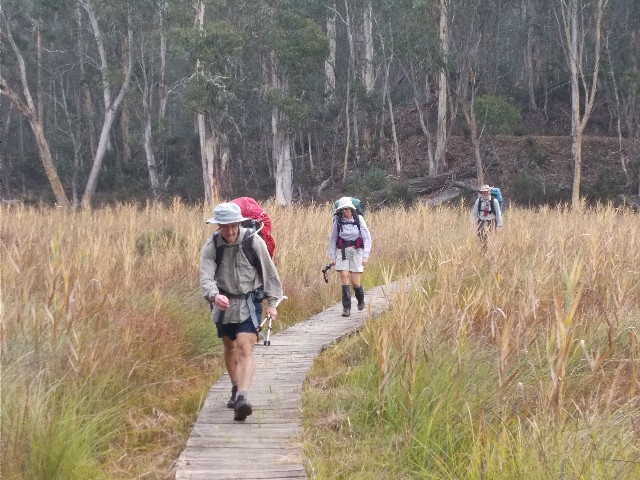
Crossing Chinamans Creek Boardwalk
I had been looking forward to seeing this and I was quite surprised at how quickly we crossed the swamp and left it behind us. I failed to get one single photograph. I was certainly expecting something much bigger. It was just two small footbridges over two wet areas. On the other side we followed more forest roads and they seemed to go on and on. We had a short rest break at 9.30am after crossing Chinamans Creek via a long boardwalk which really looked more impressive than Micalong Swamp. For all we knew it was part of the same swamplands, which it actually was.
We followed more unsealed forest roads taking us all the way to the lower slopes of Mount Nimbo. We crossed Boundary Road under power transmission lines and into Kosciuszko National Park. The day had called for 250 metres in ascents and over 800 metres in descents. I was glad we were travelling north to south. No wonder the Strzelecki boys were exhausted yesterday. The weather was fining up too and by 10.00am we were walking under a sunny almost cloudless sky. My heels were starting to hurt again even though I had taken precautions in taping the wounds this morning. Discussions with my companions revealed everyone in the group was having issues with blisters.
Near the top of Mount Nimbo we were following a track which contours just under the summit. The option to walk through open forest to take in the summit was vetoed due to the long distance we were already walking today, but we were making good time. In hindsight we could have taken an early lunch on the summit and bagged ourselves a trig point. It really wasn't too far out of our way.
We soon started the steep descent but it was split into short sections between flat level walking. When it was extra steep we needed to take extra care where we placed our feet. During the descent I kept an eye open for suitable places to have lunch, but by 12.15pm had to settle on a couple of damp logs, a rock and the grassy embankment alongside the track. I called for just 30 minutes break today and there was no suitable spot to air and dry our tents. We were even too scared to take off our footwear for fear of discovering just how bad our feet were. The blister problem was a big downer in what could have been such a fantastic day.
My left heel was hurting so much that 10 minutes after we resumed walking I had to stop and do something about it. The others forged on ahead while I dived into my first aid kit. I caught up to them 10 minutes later, laying in an open grassy paddock and soaking up the sun. The spot would have been perfect for lunch.
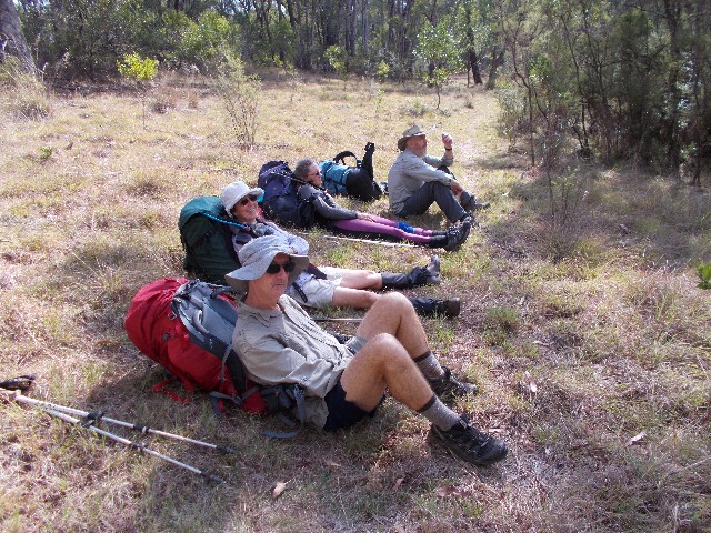
Lazing on a sunny afternoon - The Kinks relaxing during the descent from Mt Nimbo
We negotiated a steep slope of loose scree and followed a track through forest wondering when the descent would finish, even though it felt like we had only descended half the 800 or so metres so far. At 1.30pm we stepped out of the forest into a clearing called 'The Hole', where Squizz signed the logbook on our behalf. No poems for this logbook. The clearing used to be a farm where trees removed from the forest to create farmland created the Hole in the forest. It was settled by Jim McNamara in 1888. He was a shearer who disappeared for six months of the year, usually returning in time for Christmas. He fathered 13 children here, all of which worked as a labour force on the small farm. We felt that this area would serve perfectly a spot as a camping area. Just add a toilet, shelter and water tank, even if it is only 6.5km from our destination today. We were to find that would have been a great idea as it was the longest and hardest 6.5km walk most of us had ever taken.
The trail took us through tunnels of tea tree and then descended long and hard though helped by track benching and zig zags through the forest of eucalypts and blackberry to reach Stony Creek. We had a break here to replenish our almost depleted water supplies and I was glad we did. The track now ascended steeply to the next ridge, then descended to another minor creek before ascending yet again. In all our planning and looking at the main descent we had failed to notice the sting in the tail of today's walk, thinking we had tackled the 250 metres of ascent to Mount Nimbo earlier - Oh no we hadn't. By now my feet were agony and now my right heel was blistering. I was aware that Julie was also doing it very tough and really struggled on these last ascents.
Despite being in front I barely shuffled my way up the final ascent. At least the descents took pressure off my heels. The final descent seemed to take forever, but suddenly I stepped out onto a bitumen road, crossed over then negotiated a stile into Thomas Boyd Trackhead camping area. Before going any further I allowed all my companions to catch up and head into the campsite ahead of me. It was 4.40pm. We had just completed one of the hardest days of the entire walk.
We wasted little time in getting our tents pitched on the grass to dry while the sun was still out. My tent required extra help with a towel it was so drenched. I took a Hydralyte drink then looked at my feet. They were in shocking condition. Both heels had the skin peeled off them and new blisters were forming on the raw skin below. I was going to have to do some serious strapping before tomorrow's 20km walk. My back was also very sore from carrying the rucksack today and my hips were badly chafed where the hip belt had rubbed, having to keep the belt tight to stop the pack from dropping below my hips. I'm really starting to be convinced this was a very bad purchase, it was obviously the wrong size for me. Squizz amazed everyone by going for a late afternoon swim in the adjacent Goobarragandra River and returned stating how refreshing it was. I was too concerned with blisters to worry about late afternoon swims.
We busied ourselves drying our damp gear, but the sun set over the ridge before the job was complete, my tent remained damp but still good enough for a good night's sleep. Instead we prepared our meals as the daylight slowly disappeared. While we were eating the Ranger showed up to collect camping fees and we chatted to him about the track. He was very interested in the track conditions and we gave him plenty of information. We were all in our tents by 7.15pm, hardly surprising after today's effort.
I was up again just after 6.00am on day 8 and greeted by a clear sky but almost freezing temperatures. I started to fix breakfast and was soon joined by Squizz, Gerald, Jacqui and then Julie. We wanted to wait until the rising sun came over the ridge to dry our tents, but this was taking too long so we packed up our damp tents, hoping to dry them later. Most of us tended to our now sore blistered feet, especially Julie and myself, who seemed to have the worst of it.
We headed off out of Thomas Boyd Trackhead at 8.20am. Our first task was to cross the suspension bridge (Norm Harris Bridge) over the Goobarragandra River which was no problem. I was more worried about the swing bridge (Jack Cribb Bridge) further upstream. These two bridges are named after local landowners who allowed the HHWT to pass through their properties. We followed a trail beneath a canopy of elm trees before following a steep trail through private property alongside the river, eventually arriving at the swing bridge. The bridge is made up of steel rods, wire and cables.
Jacqui went first, followed by me. For years I had been fearful of crossing the bridge and today was the day I faced my fears. I watched at Jacqui crossed, noting how much the bridge bounced and swayed. This was going to be hell on my nerves and the only reason I was standing here ready to follow was the fact that in Australia, no one would allow us to be crossing an unsafe bridge. As soon as Jacqui had reached the other side it was my turn.
My heart was in my mouth as 20 steps in I was wondering what the hell I was doing here, but by the time I decided to turn around and chicken out I was already 1/3rd across and turning around would probably make the bridge lurch and sway. I gritted my teeth, held onto the hand lines, kept my eyes on where I was putting my feet and concentrated on steady breathing. I had been told not to look down, but when I accidentally did I found I wasn't as scared as I had anticipated. The worst part was the bridge swinging and swaying as I attempted to cross slowly but steady. I gained more confidence as I got to the last third, but I was really happy to eventually step off onto the solid ground of the far bank.
I took photographs of the others crossing, first Julie, then Gerald, who amazed me by being as slow as I was, and finally Squizz who stunned everyone by practically crossing the bridge at a trot. He was so fast and the bridge swayed so much we thought he was going to bounce over the hand rails and into the river. Gerald stated that he had crossed many similar bridges in New Zealand, but this bridge was in the worst condition of all of them.

Gerald crossing the Swing Bridge over the Goobarragandra River
We now took the footpad alongside the river for a short distance before ending up on the bitumen road for a 100 metre stretch before turning left onto a farm trail and again crossing the river via Buckleys Bridge (Perhaps a better name for the swing bridge) From here we walked several kilometres along farm roads as the trail followed Walls Creek. We crossed fence lines using stiles. Most of the livestock was either sheep or cattle or both. It was hot walking in the morning sun but we made good time.
Eventually, as we came close to a farm residence just after the remains of an old sawmill we left the farm road and followed a foot track that took us across the creek and then ascended very steeply up a bushfire burnt ridge for quite some distance. The going was tough, not just from the heat of the day, but those of us suffering from blistered heels. That damned rucksack was starting to become very painful on my chafed hips too. Walking uphill was the most uncomfortable experience as your feet slide into the back of your boots. I had found a way of walking that kept my feet to the front of my boots by kicking forward, but that just hurt my toes and I ended up shuffling sideways as we climbed, which did help, but slowed me down.
The narrow track just kept ascending and we wondered when we would reach the top. We passed through granite rock outcrops and bushland dominated by the black boy which seem to thrive on fire to regenerate. At 12.15pm we found a shady spot to sit and enjoy lunch for 35 minutes. The cool breeze here was invigorating. When we continued the track descended and we soon found ourselves back on farmland not far from Foxes Gap and following the white Hume and Hovell Track marker posts through the open countryside. This was hilly countryside and our main companion was an electric fence. That and dodging the many cow pats that littered the track. There were many stiles to cross and with the grassy hills, tested not only our fitness, but also our damaged feet. We soon descended to a stony farm road and thinking we were close to the Snowy Mountains Highway, set a fast pace.
Somehow, we easily missed a marker post (It wasn't me, I wasn't in front) and we ended up walking 500 metres before I realised we had missed a turn. A glance at my GPS revealed our position was well away from the official route. We back tracked until we caught sight of the post and followed the line of white HHWT posts now seen clearly, across the countryside. We were disheartened to find ourselves faced with yet another steep ascent through another paddock, but what was worse was the biggest hill saved for last.
This hill was huge, and steep, but easily could have been negotiated by following a level contour to end up at the same spot. Breathlessly we made our way to the top where we finally got a view of the Snowy Mountains Highway. We wondered why we seemed to finish each day with such big ascents. Were the people who planned this track sadists? We descended the hill to the road to be greeted by Craig Rayner who was providing support for this hike. He handed each of us a can of flavoured mineral water which really went down so well. It is exactly 3.00pm as we step onto the highway.
Craig now had the duty of ferrying us to our cabins at a local Tumut caravan park where some of us would be staying for two nights. Jacqui and Gerald have just finished their walk and Julie has hit the wall with her bad feet. Craig takes them first while Squizz and I walk the approximate 500 metre section of highway to East Blowering Road where the Hume and Hovell Track will recommence on Wednesday after our rest day. There is no doubt that the section from Wee Jasper to Tumut is the hardest of the entire walk. I can now say that that in hindsight after having completed the entire trail. It wasn't just the foot problems. The ascents, narrow eroded tracks and the state of some of the foot bridges on this section along with the steep descent from Mt Nimbo made this an unforgettable walk that really stretched our resources and fitness.
We wait here for Craig to return. It had taken just 10 minutes to get to this junction. When we get to the cabins we gladly release ourselves of our rucksacks and set up our tents on the grass to dry. Next, a shower and change of clothes is organised followed by treatment of my blistered feet. Everyone has suffered from blisters this hike. Julie's are so bad she has decided to pull out of the walk at this stage and will head back to Canberra with Craig, Jacqui and Gerald tomorrow. She will look to rejoin us for the walk from Tumbarumba in a week's time if her blisters heal up satisfactory. Julie will have time to treat her feet and purchase better footwear for the last section. (Sadly, Julie was to withdraw completely and fly home to Queensland on the day we recommenced the walk from Tumbarumba as her feet refused to heal in time) All that is left is for me to unpack my food drop and change rucksacks and boots. Everything appears to fit perfectly into the reserve pack.
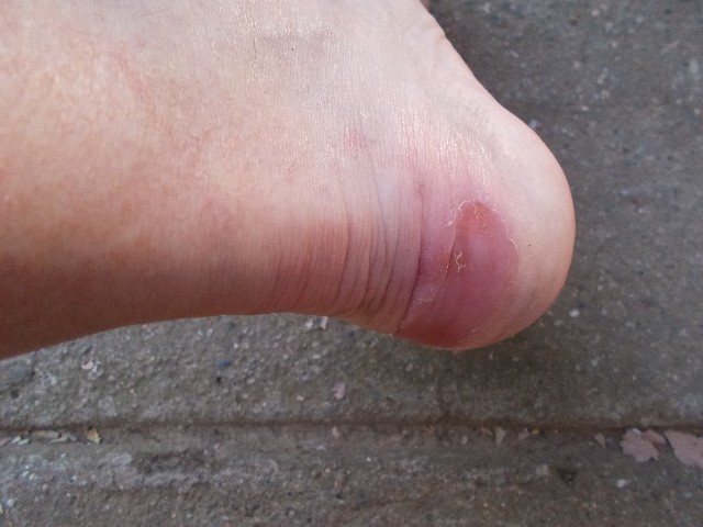
One of my blistered heels
Day 9 - Thursday 24th April is our designated rest day. Squizz and I put together our foods, brought in by Craig yesterday afternoon. Before Craig returned home he dropped me in Tumut so I could make some first aid purchases, especially those items required for blister treatment. I picked up something for lunch and took a look inside Tom's Outdoors shop and left suitably impressed. As expected, when I returned to the cabin just before lunch, Craig, Julie, Jacqui and Gerald had all left. Our dirty hiking clothes were washed at the caravan park's laundry during the afternoon.
I treated my blisters using an old bushman's trick. Using the peel of an orange, I taped the peel to the sore parts of my heels. The peel is supposed to aid the recovery of the wound. Tomorrow's walk is mostly flat and short in distance so I'll see how everything is when we get to camp tomorrow afternoon. Squizz believes I should have pulled out with Julie. He had seen how badly I was suffering from the pain in my heels during those ascents yesterday, but I wasn't giving up. After enjoying a steak sandwich cooked in the barbecue area we now waited for our next companions to show up. Sean and Julie Sunley were driving in from Wagga Wagga after work and leaving one of their vehicles at Tumbarumba before driving here. They arrived at 7.45pm.