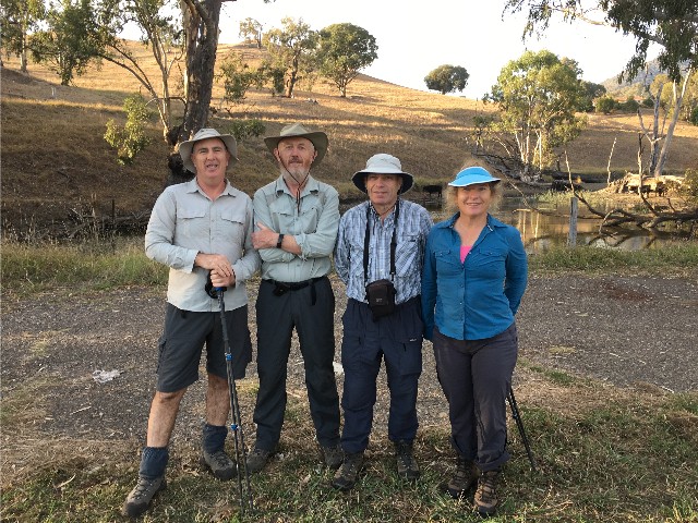
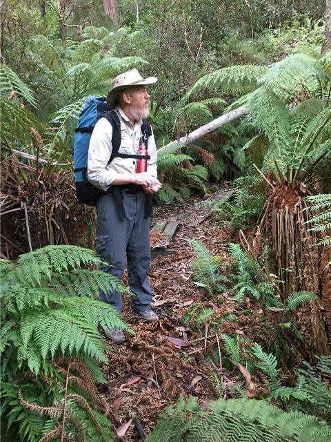
Day 1 of section 3 and new companions. L-R: Sean, Squizz, Paul & Julie
Part 3: Tumut to Tumbarumba
Day 1 of section 3 and new companions. L-R: Sean, Squizz, Paul & Julie
Squizz and I were surprised then 10 minutes later when a vehicle pulled up beside us and out got Sean and Julie. The driver was a tenant at the holiday park who had kindly offered to drive them to the meeting place rather than a long walk along the bitumen. At 8.10am we were making our way beside the fast flowing Tumut River towards Blowering Dam. It was a bitumen road again, though I didn't have any issues with my blistered heels, I had loosened my laces until I put my pack on but then found I needed to tighten them. I found this was very comfortable and all I needed to adjust now was the replacement rucksack which didn't take too long.
After scaring the hell out of a wallaby munching his breakfast on the roadside, we passed a cattle farm and the rock wall of the dam came into view, as did the suspension bridge over the Tumut River. It was identical to the one we had crossed immediately after leaving Thomas Boyd Trackhead, only this one was longer and narrower. I crossed it first and waited for the others.
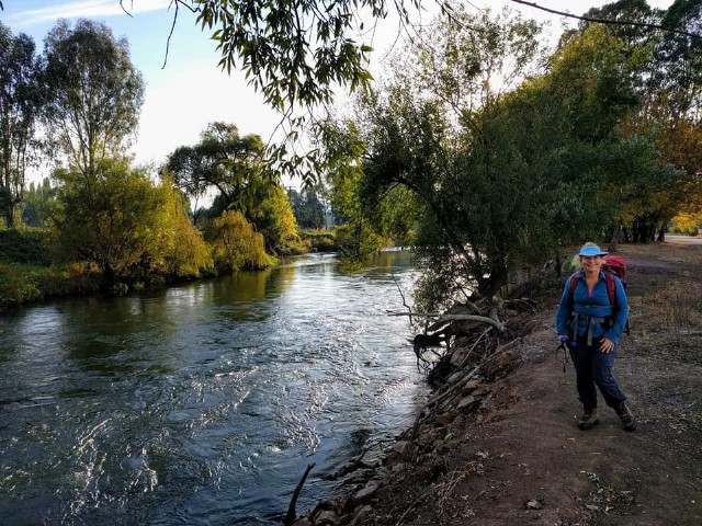
Julie Sunley on the banks of the Tumut River. Photo: S Sunley
We walked past the old Snowy Mountains Trout Farm and into the Blowering Dam Camping Area immediately below the dam wall, then passed by the water overflow outlet where we viewed details of the Snowy Mountains Electric Scheme. A track then ascended steeply beside the dam's right side and we were soon standing in the car park atop the Blowering Dam wall. My ankles rubbed during the ascent and I feared I had done more damage, but 10 minutes later at 9.20am when we arrived at Blowering Camp, a check of the strapping on my feet revealed all was okay.
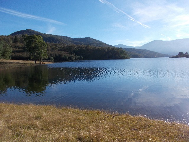
A 20 minute break was enjoyed before we followed the track alongside the reservoir's western bank. Like Lake Burrinjuck before it, the water level was way down. This is a section of the Hume and Hovell Walking Track I have walked several times with the Shoalhaven Bushwalkers while staying at Laurel Hill. We followed the track for some distance, almost 8km before deciding to sit on a grassy embankment at midday to enjoy a 40 minute lunch break, watching the cars making their way along the Snowy Mountains Highway on the eastern side of the reservoir. I had noted that there had been some track maintenance here since my last visit. The rotted wooden footbridges had been replaced with new crossings.
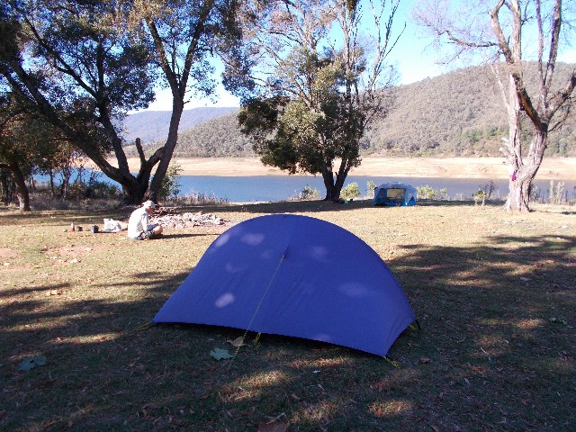
When we started walking again we only had a couple of kilometres to walk before we arrived at Browns Creek Camping Area at 1.30pm. I was surprised by this camping area. The main grassy area sits beside Browns Creek which is presently dry. The camping area is dotted with Wombat burrows, but there is a fire place next to a covered picnic table and beyond that a fresh water tank. The toilet is strangely positioned. We have to cross a narrow wooden footbridge and climb a steep ridge through nettles and surrounded by blackberry vines to reach the dunny door. We immediately pitched our tents and then Sean, Julie and Squizz took the long 1km walk to to the reservoir to have an afternoon swim. I decided to stay at camp and kept myself busy collecting firewood for the campfire.
I also removed my boots and dressings on my heels to check the blisters and was amazed to find they had completely healed. The orange peel had worked perfectly. My thoughts went straight to Julie who had pulled out because of her blistered feet and I wondered if she had used the orange peel would she have been able to continue. I made sure there was extra peel in my pack in case it was required further on, but I ended up binning it a few days later. I had no further issues with blistered feet for the remainder of the walk.
The others arrived back from their swim one hour later and were astounded by the amount of firewood I had collected. Probably enough to last 3-4 nights, though I do practice leaving enough for the next campers to come through, you never know if they are going to arrive after dark. We had a late afternoon cuppa then started preparing dinner. As darkness fell we stood by the fire chatting until Sean & Julie retired to their tent at around 6.30pm. Squizz and I retiring to our tents one hour later after a long discussion about our options tomorrow.
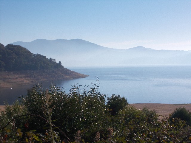
"Smoke On The Water" Blowering Reservoir near Browns Creek Campsite
Day 11 found us all up under another perfectly blue sky at 6.15am. Breakfast was fixed and camping gear packed up. We headed out of Browns Creek Camp at 8.05am and followed the track that Sean, Julie & Squizz had taken yesterday for their swim. The views to the reservoir revealed what appeared to be a thick mist covering the water. We later realised this was actually smoke from the clear-up fires where pine harvesting had been undertaken further along. The track ascended a small hill where it met a forestry road, which is what we ended up walking on for the entire day. It wasn't too bad really. We basically found ourselves Nordic Walking as the roads took us through picturesque shaded pine forest. The temperature was cool so we could put the pace on a little.
Sean and Julie fell behind immediately, not used to mine or Squizz's pace, and to be fair, we'd had a week's start on them in terms of track fitness. We would wait for them to catch up, continue on and they would fall behind again. Even Sean and Julie agreed that their legs felt like concrete and it concerned them. I assured them they would be fine after a couple of days. We took 10 to 15 minute breaks every hour, but soon Sean came up with a suggestion that made some sense.
We were nearing a section of the track where a short cut route would cut 5km off the day's length and would rejoin the trail just before our new planned campsite at Yellowin Forest Park. The detour was not part of the Hume and Hovell Track and although I was loathe to split the group up, I had good faith in Sean's navigational abilities, so agreed. Squizz and I would continue following the official track and we estimated we should all arrive at our destination at about the same time.
We split up at a grassy area near Cannons Bay where, in 1978, Ken Warby launched his boat prior to setting a world water speed record that still stands to this day. We now had our best water views since leaving Browns Creek Campsite this morning. Sean and Julie walked down to the waterline to have a short break while Squizz and I continued on. As we came around a bend in the road we were greeted with the sight of two large Emus who quickly retreated into the forest. Until we reached camp this afternoon we would have good views of Blowering Reservoir, even through the pine trees along one section where I took the opportunity to take the only Selfie with my iPhone during the entire walk.
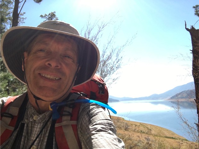
Paul's selfie with Blowering Reservoir in the background
Squizz and I stopped for lunch along a section of road dominated by pine trees. We chose to sit on the needle covered forest floor, there was no fallen logs or stumps to sit on along this section but it was quite cool in the shade. Little were we to know that Squizz lost his penknife during this rest break. Something that constantly irked him, even after purchasing a replacement at Tumbarumba later in the walk.
After 25 minutes we continued on and soon found ourselves walking in open countryside in the heat which became quite uncomfortable. Where we could, we aimed to walk along shady spots where the temperature dropped immediately. We passed by Island Forest Park, our original planned campsite for today, it wasn't even 1.00pm. We could now look over the water at the ridge we would be ascending tomorrow and to the south to what appeared to be open grassy areas. We became concerned that none of the camping areas we passed along here had names and there was little to tell us we were still on the Hume and Hovell save for the regular white posts. After turning left at a junction we walked past a grassy area that featured a toilet building. Squizz was certain he had seen two in the distance and as we passed a small grove of trees we spied the second building and just beyond that, beside a very large tree we saw the familiar sight of Sean and Julie putting up their tent. At 1.40pm we joined them at the new campsite.
I was pretty sure this wasn't Yellowin Forest Park, but it was a lot closer to Ben Smith Campsite than Island Forest Park was. It meant a shorter day tomorrow prior to ascending Gurkeroo Ridge. After putting up our tents we walked down to the reservoir for an afternoon dip, wash clothes and collect drinking and cooking water. Our campsite was windy and leaves were blowing everywhere. We had views south that included several campsites in the distance and where smoke was billowing from forestry clearing operations. This also explained the conditions we had seen on the water this morning.
The campsite at Dormans Point
One of my walks around camp revealed a vegetation covered sign that revealed our campsite was on Dormans Point which was several kilometres north of Yellowin. The area was dominated by eastern grey kangaroos which could be seen hopping around the nearby grasslands. As usual Sean had got a good fire going, the wind was drying my washing which was hung on a nearby tree branch and we enjoyed an afternoon cuppa pondering which section of ridge our track would ascend tomorrow. After cooking up dinner and standing around the campfire chatting the temperature dropped off dramatically as the darkness fell so we all retired to our tents.
Day 12 greeted us with yet another cloudless sky and probably the coldest morning so far. We really have been lucky with the weather on this trip with only a 30 minute downpour on the morning we left Barrois Camp. I was awake by 5.30am and up by 6.20. A thick mist floated on the reservoir below us. We waited for the sun to come up and dry the dew on the tents this morning. By 8.20am Squizz and I were packed and ready to head off. Sean and Julie had left 10 minutes earlier to get a head start. I was held up after one of my boot laces broke. Luckily I had spares in my emergency kit.
10 minutes later we caught up to the Sunleys and noticed why they had stopped. They were standing in front of a sign that stated "Yellowin Forest Park". As we guessed, we had camped too early yesterday. Though it looks like we may have chosen the better spot, we could not see any toilet building. Two Gang Gang Cockatoos put on a show for us in a nearby tree. The birdlife here is amazing. We continued on passing many more camping sites, most without toilet blocks. We're still following a forest road as it curves around the small bay we had camped beside to reach a small peninsula which the trail follows around the waterline. We passed a section where recent hazard reduction burning had been undertaken, then suddenly a track marker directs us onto a short foot track which cuts out a section of roadway.
We cross a small creek on a very stable looking wooden footbridge, then rejoin the main road. A HHWT signpost directs us to cross the road and follow and old trail on the other side which starts to gradually ascend. The trail soon widens into what is obviously an old unsealed road as it ascends towards Gurkeroo Ridge. Here the real climb begins. It really wasn't as bad as we had expected, the ascending was gradual as the trail zig-zagged in a series of benched routes. Along the way we got a couple of tree interrupted views back across the reservoir to where we had camped last night. At around 10.30am we easily arrived at what appeared to be the top of the ridge and we stopped for a well earned rest.
What remained, we thought, was the easy descent to Ben Smith Campsite, a walk of approximately 8km. We commenced descending to a road junction, then the trail ascended again, descended into a shady cool section of forest and then uphill again we went. We followed a wide open dirt road and passed under the power transmission lines we had seen yesterday from camp and ascended to a four way intersection where a Hume and Hovell signpost directed us to follow a foot track that started to descend into the forest below one of the roads. After a few hundred metres we came to a spot in the forest that looked suitable for us to stop and have lunch for 35 minutes.
When we continued we followed the track as it descended through a forest of blackberry vines. It was blackberry as far as you could see into the forest. It was depressing to think how badly this introduced plant could take over so easily. I always thought the sections of track near Tumbarumba were bad, but this beats them all. It only seemed about 20 minutes since we left our lunch site and suddenly we stepped out onto Ben Smith Campsite. We were stunned as it didnít represent what we had visualised. We had expected a large level camping area on the water's edge with views up the reservoir and across to the town of Talbingo. What we found was a small split level campsite in a valley between two ridges. Squizz and I had also walked 200km since we started this hike near Yass on April 16th.
Jounama Pondage from the HHWT
The creek bordering the campsite was bone dry, but the water tank is almost full. We have a covered and uncovered picnic table, several BBQ fireplaces and a toilet. It looks like a fallen tree hit the roof of the toilet as there is a big dent in it. The door is quite warped and very hard to open and upon entering I was greeted with a toilet seat, split in two that had a rock on it. When I removed the rock it revealed two large red back spiders, not the perfect situation to be greeted with. I killed the two spiders and sprayed Bushman repellant around the seat in case there were others around.
We all pitched our tents down the bottom of the hill, just above the dry creek. The grass was short here and the tent pegs went into the ground quite easy. Sean and Julie and then Squizz headed off to find the reservoir and go for an afternoon swim. I was content to keep myself busy by again collecting the firewood for this evening's campfire. I also explored the small ridge above the creek and ended back on the track we had walked in on after battling through some blackberry. The others returned from their dip revealing it was about 20 minutes walk from the campsite. By 4.30pm we had started the fire and were preparing dinner and by 5.45pm everyone had eaten. This was the first campsite where we noticed the name 'Uggy' written on the beams of the shelter. We were to see Uggy's name and numbered day at every campsite for the remainder of the walk and wondered who Uggy was and when did he/she do the walk. Squizz and I stayed up until 7.40pm by the campfire chatting away despite the dropping temperatures.
Despite the cold night I had a great night's sleep, waking up at 6.15am and tempting fate with a visit to the spider infested toilet. Everyone else was getting up when I returned to camp. Another clear sunny sky greeted us as we fixed ourselves breakfast and broke camp. Sean & Julie again had a 10 minute start on us by leaving camp at 8.05am while I was still taking down my tent. Squizz busied himself by putting out the campfire while he waited. Today (Day 13) was only a 14km walk, but we had a 660 metre ascent into the high country to deal with.
We caught up with the Sunleys within 15 minutes after following the track to a dirt road. Squizz informed me they had turned left to go for the swim yesterday, but the signpost called for a right turn and we ascended the hill for a short distance before turning left onto a track that took us onto farmland where we joined Sean & Julie. This is cattle country and dodging cow pats became the order of the day. We followed an undulating route marked by the white HHWT posts and enjoyed the views of Jounama Pondage and the mountains beyond. Jounama Pondage is at the southernmost end of Blowering Reservoir and just upstream from the village of Talbingo. Big Talbingo Mountain dominates the views along with the water pipelines emanating from the big Tumut No3 Power Station.
After a quick break on some fallen tree logs we crossed the last of many stiles for a while and entered Kosciuszko Natonal Park again and followed what was once a sulky trail leading gradually uphill for quite some distance, but it was easy walking and no one fell behind. I let Squizz go in front for a while and he caught sight of a large feral pig running through the forest and down the hillside as we approached.
As we got higher, the trail narrowed into what became a bridle trail used to ferry tourists to Buddong Falls back in the 1890's. The trail was narrow and benched above a steep drop into the forest. We had to take care with our footing in the stony leaf littered ground. For a while we appeared to be walking on a level contour but trees blocked the views. Soon we heard the sound of loudly rushing water. We were getting closer to the lower cascades of Buddong Creek.

Buddong Falls
We crossed the creek via the steel footbridge at Moffatts Crossing, noting the Logbook there which had no pencil or pen to write with and suddenly the ascent changed as the track got much steeper, zig-zagging its way up the ridge and revealing views of the cascades below us. The drop from the narrow track was extremely steep so we concentrated on keeping our eyes on the narrow trail in front of us, stopping only to take in the views. At a couple of sections there were rocks and eroded track to be negotiated and this was with the assistance of ropes staked along the track.
Views down the valley featured Big Talbingo Mountain and we could still see the water pipes at the power station. Then we started steeply ascending again above and beside the Buddong Creek cascades and the lower falls came into view, sadly tree interrupted. Sean was amazed at how much water there still was coming down the cascades despite the drought conditions. The best was saved for last though, making the ascent definitely worth the effort. Near the top of the ascent we were treated to great views of the main Buddong Falls.
The narrow track continued to ascend to cross a footbridge over Buddong Creek and suddenly we found ourselves in Buddong Picnic Area where, at exactly 12.00pm, we stopped for a 50 minute lunch break. We gathered water from the creek, hung out our sweat soaked shirts to dry in the sun and enjoyed our lunch while seated at a park picnic table. We were now in the highlands and heading for the highest point on the track.
Our talk turned to the rest of our walk today. Original plans were to camp at Buddong Hut, 3.5km away, but I liked the idea of walking the 11.7km to Paddys River Dam where there was an official campsite and we all seem to be walking well. Did we have the time? The general concensus was "not really", it looked like another early arrival into camp this afternoon. There was no rush though, we are really enjoying this long distance walk and there have been no further issues with blisters or with heavy ill fitting rucksacks.
After the picnic area the track ascends gradually to meet up with another forest road. We follow this through an avenue of blackberry until, as we came over a crest on a hill, saw Buddong Hut through the trees and across the way to the left. We descended to it, arriving at 2.20pm. By the time we looked around the hut and had pictures taken in front of it, it was obviously too late to attempt reaching Paddys River Dam. The hut was built in 1925 to house workers who took streamflow readings in Buddong Creek. The hut has fallen into disrepair but can still be used in an emergency. Sadly, being on an access road from the nearby town of Batlow it is used by local party goers for evening parties and other goings on. The grassy area around the hut has been churned up by numerous vehicles and there's rubbish everywhere, including the remains of an old bed and lounge, just dumped next to the hut.
We looked around and found three small grassy spots that might provide tent sites and very little else. Squizz and I pitched our tents almost on top of each other and the ground was hard to get the pegs in. Sean & Julie had disappeared, looking for a spot in the forest to camp. They returned with news of an open grassy area just 100 metres south of the hut. Squizz and I went to have a look. We followed a bush track behind the hut which descended to Buddong Creek and crossed via a wooden footbridge, noticing the adjacent concrete weir, then followed a track 50 metres into the forest to arrive at a fantastic looking campsite.
We returned to our tents at the hut and wasted little time in bringing our tents and gear down to the new site. This was proper bush camping, open grassy areas surrounded by trees (Ghost gums and stringybarks) and a massive area set aside to sit on logs surrounding a campfire. This site has been used before. There was plenty of firewood around. We wasted little time pitching our tents and settling down for an afternoon cuppa before collecting water from the weir. Prior to cooking dinner we played Squizz's dice game or wrote in our journals. We noticed horse poo around camp and we came to the conclusion this site was also grazed by Brumbies, Australia's wild mountain horses. We hoped they wouldn't be running through the campsite tonight - they can become quite territorial and often trample tents placed in their territories, especially the stallions.
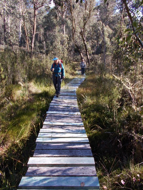
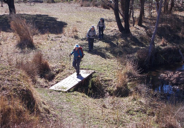
Julie and Sean crossing swampy territory on one of the many long boardwalks
The temperature dropped considerably as the sun disappeared behind the west ridge. Sean & Julie again retired to their tent early leaving Squizz and I to keep warm by the campfire chatting until well after 8.30pm. I slept well despite the bitterly cold night and for the first time on the trip my feet were cold in my sleeping bag - I will remind myself to wear my socks at night from now on. Despite our minor fears, no brumbies came charging through our campsite during the night but there was plenty of nocturnal activity judging by some of the sounds we heard.
I was awake by 6.00am and immediately set about getting breakfast. I was quickly joined by the others and soon the campfire was roaring. The sky was alarmingly overcast, but looked to be clearing by the time we had packed up and left the campsite by 9.00am. The trail had us following a foot track through the forest, ever alert for the wild brumbies that frequent this area. Their droppings becoming more numerous and fresher the further we walked. We crossed into an area where the track was extensively boardwalked over swampy ground and where footbridges over creeks became numerous. We soon caught sight of a lone tan coloured horse hiding in the undergrowth. It bolted before any of us could get a decent photograph.
Very shortly we soon came to an area on Buddong Creek that was worked by gold miners in the late 1800's to early 1900's. The cuttings on the creek where sluicing was performed helped make for some photographs and we took turns posing on the bridge above the creek. The track now became a forest road and it ascended quite steeply for some distance up the ridge before levelling out. Soon after, a familiar Hume and Hovell Track sign appeared and I recognised it as one I had passed on a previous walk here.
Turning right to follow a foot track through more forest, the track wound its way southwards around rock formations and vast plantations of the accursed blackberry, sometimes ascending as we approached the Hume and Hovell Walking Track's highest point. We then had another brumby sighting, this one a black horse who allowed us to get really close before lumbering off into the forest, but didn't go too far. This one was obviously used to the presence of humans.
The track now ascended and descended to cross two small creeks before finally ascending to reach what we believed to be the highest point on the HHWT at about 1200 metres. You would think that there would be a signpost stating this fact. The only reason I was confident we had reached the point was I had been in the company of Owen Fitzgerald (Local identity and Owner of Laurel Hill Forest Lodge) on a walk here last year. We stopped to mark the moment but in the chill air and our keenness to get walking to warm up we forgot to have photographs taken to mark the moment. This spot also marks the approximate halfway point on the Hume and Hovell Walking Track. There was only a couple hundred metres of track to follow now before we stepped out onto the intersection of Bullongra Road and Ash Creek Road.
Squizz on footbridge near Paddys River Dam
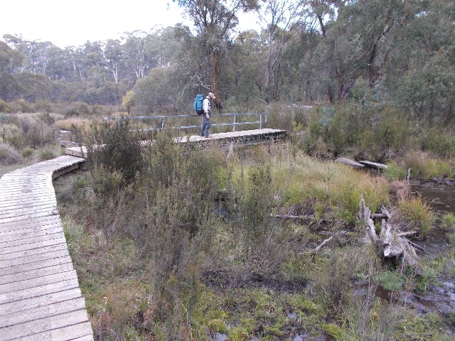
The trail went straight ahead and we found ourselves following another "No Through" forest road that took us 3.7km to Paddys River Dam Camping Area. This section of walk we noticed was very chilly, the cloud cover had returned and the strong bitter winds bit us through our hiking clothing. At 12.05pm we arrived at one of the drive-in campsites at Paddys River Dam. While Sean tested out the brand new pit toilet, Squizz and I headed out towards the overflow camping area at the far end of the dam. The track took us all the way around the reservoir on the western foot track and across a footbridge to arrive 10 minutes later at the main picnic area where we stopped for a quick lunch. Sean and Julie caught up to us soon after.
At this point I made the suggestion that required 100% agreement from the rest of my companions. Because we had arrived so early at our planned destination and tomorrow's walk would be extremely long at 29km I offered Sean and Julie the chance to shorten tomorrow's walk by walking a large chunk of it this afternoon. We had seen in the track notes that there was a suitable campsite about 8km further on near a place called 'The Coffee Pot'. Everyone was in agreement with the only worry being water availability. Track notes and strip maps suggested there would be plenty of water in the creeks, so we put the rucksacks back on and set off at 12.45pm.
Less than 4km into the walk, for the first time since yesterday morning, my mobile phone came in range of a signal and the unmistakeable tone of a text message being received. It was bad news, Julie's blisters have not healed, so she will not be rejoining us at Tumbarumba on Tuesday 1st May as previously planned and will be flying home to Queensland that day instead. The news was disheartening to both myself and Squizz as we had really enjoyed Julie's company on the first 1/3 of the walk.
The track here follows an old water race that was originally built to create a water flow that helped power electricity in Tumbarumba. It was later used by gold miners for sluicing. The water race held a lot of interest to Squizz as he had worked for years as an engineer in the water industry and he was amazed at the length of this engineering feat. If you didn't know what you were looking for you would miss this completely. The track is well defined and well marked but all the creeks we had crossed so far were dry or boggy, so we continued on with high hopes.
We passed and signed the logbook at the start of The Coffee Pot. We wondered why it took this name, there is nothing revealed in any track notes, books or maps on the area. All we could do is consider that the track here takes the shape of a coffee pot, but we still couldn't see why. We were still on the lookout for suitable campsites and running water and while we had little luck at several places where camping looked suitable, there was no water so we were forced to continue on. We had come too far this afternoon to consider back tracking to Paddys River Dam. The afternoon got later and later and we were now getting very tired. I tried to encourage my companions to continue but they were also getting exhausted. We considered the thought of just camping and having tomorrow's lunches for dinner and cooking tonight's dinners for lunch when we reach water tomorrow.
Soon we came to a forest road and the commencement of East Burra Creek. Our hearts sank, the creek was bone dry, so on we pressed. The track now became a benched track high above the valley and resembled rainforest more than dry sclerophyll. We eventually found water, a small trickle coming down a gully between some rocks. It was enough, we filled our hydration bags and bottles with enough water to get us through dinner and breakfast.
Squizz in the ferneries on the never ending benched track
The narrow track seemed to go on forever, ferns, fern trees, rotting boardwalks and wet damp scrub, the track continuing high above the valley. Now we were finding running water at every gully we passed, but no suitable campsites and the clock ticked on ever closer to dusk. We were now looking for the slightest clearing that could squeeze three tents in and couldn't do it. Sean and Julie now fell behind us as Sean's dodgy knee got the better of him. With the sun now disappearing over the western ridge Squizz and I went on ahead in the hope of locating something that would pass as a campsite while the Sunleys slowly made their way along. The biggest fallen tree I've ever seen now blocked the track and this required careful time consuming scrambling over its massive trunk.
I got far enough ahead of the others that when I stepped out onto a forest road, I dropped my rucksack and followed the road uphill for about 400 metres unable to locate even the slightest clearing that was deemed level. I returned to my rucksack and got out my head torch. It looked like we would be finding a campsite in the dark. Squizz soon caught up and also got out his torch. We discussed camping on the side of the forest road, but agreed this could be hazardous if a logging truck came along first thing in the morning.
The track on the other side of the road appeared to be heading into less wet forest that we felt could feature open grassy areas. Sean and Julie then arrived with the news that Sean just can't go any further today. I wasn't surprised, I later calculated that we had walked 25km today, the most distance we had done in a day since the Sunleys had joined us. I took one long look down the new track but returned disappointed. It was 5.00pm and getting dark. We had no choice but to camp on the walking track.
Sean and Julie already had their three person tent half pitched on the narrow track and to this day I still wonder how they managed it. It did block the entire track. Squizz and I had a hard enough time trying to pitch our one person Macpac Microlight tents on the track. They must have found the widest spot on the entire benched trail. I suddenly realised I was very tired from today's activities and for dinner decided to forego cooking and go with Sean's earlier suggestion of eating tomorrow's lunch for dinner tonight. The way I looked at it, we would be in Tumbarumba in time for lunch tomorrow, one day ahead of schedule. Between mine and Squizz's tents was a HHWT post with the number of kilometres to Henry Angel Trackhead on it. We were only 15km from the end of this section.
There were no campfires tonight and little room to socialise on this narrow track. We considered ourselves fortunate to have got this far and to locate a dryish campsite, though maybe the lesson here is to stick to original plans. However, who would have thought the early creeks would be so devoid of water. I'd never seen them dry in 3 previous visits to the Paddys River Dam area. We were all in our tents just after 6.00pm and I fell asleep almost immediately, though the sound of falling timber in the forest nearby woke me up I managed to sleep through the night, waking up at 5.45am. It hadn't been a cold night and for once there was no condensation on my tent. Fixing breakfast in the dark was a new experience and I was packed and ready to leave by 7.00am. Sean asked for an extra 30 minutes and got 35.
It was day 15 - April 30th 2018 and the sky was a brilliant blue yet again as we made our way through the forest. I kept my eyes open for the first couple of kilometres expecting to see the perfect campsite, but none were revealed. We quickly reached the 12km post and wondered what happened to numbers 14 and 13 as the trail took us past the area where Hussells Sawmill once stood. Angrily the remains of this historically important workplace are hidden under acres of blackberry vines.
The Hume and Hovell Track now follows a grassy route along no man's land between pine forests and the foot track has become another forestry road, though its grassy surface is easy on the feet. The grassy surface also attracts other beings too. Squizz and I came over a small rise to come face to face with a black brumby stallion guarding his mares. He approached us, snorted, stamped his hooves and shook his head. We stood our ground defiantly and the stallion backed off before running off with his brood. We followed the trail until it became a track and descended to cross a wooden bridge over East Burra Creek and we arrived at Junction Campsite at 9.40am.
There is a signpost here that states that Hume and Hovell's party camped here during the 1824 expedition. We stopped here at the covered shelter for an extended break of 50 minutes, knowing we had only 6.5km of easy track walking to finish this stage of the walk. For some it was a chance for a late breakfast, for others an early morning tea. Some took the opportunity to finish off the remaining food and lighten their rucksacks. The campsite has a drop toilet, covered and uncovered picnic tables and fireplaces, but no water tank. Both East and West Burra Creeks join here and flow past the campsite so clean running water is readily available.
When continuing we crossed Burra Creek at the southern end of the campsite via another wooden bridge and followed the track through forest that paralleled the creek. Squizz noticed juvenile trout swimming up and down the creek, so fast that if you blinked you missed them. The track also passes through an area where gold was mined almost 100 years ago as we passed cuttings and sections where rock walls had been built to stabilise the creek bank before coming out onto an open area where I noticed there had been changes to the track alignment.
I had done this section of the walk as day walks with the Shoalhaven Bushwalkers many times during the Laurel Hill visits and there were several changes made where the track negotiated difficult creek embankments or where turn-offs were often missed and this was the case almost right up to the end of the track at Henry Angel Trackhead. It was almost like following a brand new route, almost.
Julie Sean and Squizz negotiating farmland not far from Henry Angel Trackhead
As the new alignment came to a rise near the edge of a pine forest we noticed more brumbies grazing above us next to the fenceline. I was able to take a couple of photographs before they disappeared back into the forest. We now negotiated our way through farmland where cattle grazed by the track. The area also featured remnants from the gold mining era and that included parts of an impeller and sections of landscape that were irreversibly changed by sluicing and water blasting. By this time I had decided to step back and allow Sean and Julie the chance to walk in front and dictate the pace. There was no need to rush.
After crossing a swampy area using boardwalks we finally arrived at Henry Angel Trackhead at exactly 12.00pm to find Sean's car untouched, despite the fact that the passenger side front window had carelessly been left open all week since the car was left there last Tuesday evening. We all congratulated each other on an excellent job in finishing the walk to this point, one day earlier than planned and Sean & Julie had completed 100km since they joined Squizz and I.
Sean and Julie drove us into Tumbarumba where Squizz and I booked ourselves into the bunkhouse at the local caravan park where we would enjoy a full rest day tomorrow while awaiting Craig to arrive with our final food drop and our last companion Jennifer Himmelreich who is joining us for the final 8 days of the hike, We farewelled Sean and Julie who are leaving us at this stage to return home to Wagga Wagga after picking their other other car up from the caravan park in Tumut. Squizz and I utilised the extra spare time to get our laundry done, check and clean some of our gear, stock up on some snacks for the walk and in Squizz's case, purchase a new penknife.
Tuesday May 1st 2018 and the official second rest day of this hike. Squizz and I spent the day exploring the town of Tumbarumba and savouring the delights from the local bakery and bottle shop. Late in the afternoon fellow Shoalhaven Bushwalker Jennifer Himmelreich arrived, closely followed by Craig Rayner from Canberra with our final food drops. Craig also picked up my recovered trekking pole that the Strzlecki group had found and dropped off at the motel in Yass. We all enjoyed a barbecue, comprising some sausages with salad provided by Craig and cooked from the camp kitchen. The night before setting off again was marred only by a bout of stomach flu on my part that had me up much of the night.